Tohoku, Japan 2011 (Earthquake Case Study) | AQA GCSE 9-1 Geography
Case Study of the Japan 2011 earthquake in Tohoku.
This is the sixth video for the AQA GCSE 9-1 Geography course, and the sixth video of the Challenge of Natural Hazards topic.
The Challenge of Natural Hazards Playlist:
» https://www.youtube.com/playlist?list=PLWsYRBnBKKru_lB5bYtrxSEWqusxpPmc7
Follow me on all platforms:
» https://linktr.ee/keducate
Do you have a video suggestion?
» https://forms.gle/gxc3xHQ1b1wUeANT9
00:00 Background and causes
00:37 Primary impacts
00:52 Secondary impacts
01:11 Immediate responses
01:23 Long-term responses
01:37 Extra information
01:52 Outro
Video script:
On the 11th March 2011, Japan was struck by a magnitude 9 earthquake followed by a tsunami.
Japan is located on the eastern edge of the Eurasian plate. The boundary between the Eurasian and Pacific plate is destructive, with the oceanic Pacific plate sinking under the continental Eurasian plate. The earthquake occurred at 14:46 local time, with the epicentre located 70 km east of Tohoku and the focus at a depth of 29 km. This was followed by a tsunami that reached up to 40.5 metres high and travelled up to 10 km inland.
The primary impacts include:
» 16,000 deaths
» 10% of all fishing ports were damaged
» 400 km stretch of coastline dropped by 1.6m
» Damaged nuclear power plant at Fukushima
The secondary impacts include:
» The tsunami
» 19,000 homes were left without clean water or electricity
» 70,000 people had to be evacuated due to the damage at the nuclear power plant.
» Estimated cost of £182bn
The immediate responses include:
» Debris cleared within 2 days by the Japanese Army
» 116 countries and 28 international organisations offered assistance.
The long-term responses include:
» New tsunami walls being constructed 25-30m high
£25 million warning system revealed in March 2013
96% of electricity restored by november
As a high-income country, Japan is very good at responding to and preparing for natural hazards . Many buildings are earthquake resistant, and the people are educated about hazards, for example September 1st every year is Disaster Prevention Day.
--
GCSE Geography
29/04/2020
Keducate
Видео Tohoku, Japan 2011 (Earthquake Case Study) | AQA GCSE 9-1 Geography канала Keducate
Показать
Комментарии отсутствуют
Информация о видео
Другие видео канала
 Evidence of climate change #shorts #gcse #geography #climatechange
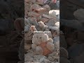 Types of natural hazards | 2024 GCSE Geography Exams #gcse #geography #aqa
 Plant & Animal Adaptations in Hot Deserts | AQA GCSE 9-1 Geography
 Urbanisation: Natural Increase & Push/Pull Factors | AQA GCSE 9-1 Geography
 Hot Desert Characteristics | AQA GCSE 9-1 Geography
 Caves, arches, stacks and stumps formation | 2024 GCSE Geography Exams #gcse #geography #coast
 Dams and reservoirs | 2024 GCSE Geography Exams #gcse #geography #aqa #river
 River erosional processes | 2024 GCSE Geography Exams #gcse #geography #aqa #river
 Flood Management: Soft & Hard Engineering | AQA GCSE 9-1 Geography
 Challenges in Mumbai (Mumbai Case Study Part 3/4) | AQA GCSE 9-1 Geography
 How climate change affects tropical storms | AQA GCSE 9-1 Geography
 Rainforest animal adaptations | 2024 GCSE Geography Exams #gcse #geography #rainforest #toucan
 Managed retreat | 2024 GCSE Geography Exams #gcse #geography #coast #sand #beach
 Bangladesh cyclone adaptation example #shorts #gcse #geography
 Tropical Rainforest Characteristics | AQA GCSE 9-1 Geography
 Magic stones in Burkina Faso | 2024 GCSE Geography Exams #gcse #geography #desert #burkinafaso
 Weathering | AQA GCSE 9-1 Geography
 Coastal Erosional Landforms - Stacks, Arches, Caves & Wave-cut Platforms | AQA GCSE 9-1 Geography
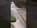 River embankments | 2024 GCSE Geography Exams #gcse #geography #aqa #river
 How are tropical storms measured - the Saffir-Simpson Scale explained #shorts #gcse #geography
 Types of coastal erosion | 2024 GCSE Geography Exams #gcse #geography #coast #erosion