How to Calculate Stream or drainage Length and Density in ArcGIS
You will learn how to calculate drainage or stream length and density using ArcGIS.
Delineating Watershed: https://www.youtube.com/watch?v=JAQVT4z8ZEw&t=6s
Download DEM Data: https://www.youtube.com/watch?v=DSSQ0HrT9bg
Why is stream density important?
Stream density, also known as drainage density, varies from watershed to watershed depending on infiltration capacity, or the ability of the soil to absorb water. When infiltration is low, water will flow overland and form streams. Certain kinds of geology (like sand, gravel, or limestone) have high infiltration, while others (like shale or clay) have low infiltration. Watersheds with high stream density have higher runoff and land that is more susceptible to erosion. Topography and slope also influence infiltration, with greater stream density occurring in areas with steep slopes. High rainfall tends to increase stream density, but in areas with the highest rainfall, stream density may be reduced; dense vegetation in these rain-prone areas reduces overland flow and increases evapotranspiration (the transfer of water from the earth to the atmosphere through evaporation and transpiration of plant leaves). Stream density is an important watershed characteristic that can be an indicator of potential water supply (Source: Enviro Atlas, USA).
How can I use this information?
The map, Stream Density, can be used to compare opportunities for recreation and water supply in different watersheds. Watersheds with high stream density provide more opportunities for birding, boating, fishing, swimming, and hunting. High stream density is also indicative of the potential for plentiful water supply (Source: Enviro Atlas, USA)..
I hope now you got the clear idea how to calculate stream length and density in ArcGIS. If you liked this tutorial, you can Subscribe this Channel and get more essential Tutorial on GIS & Remote Sensing.
Thank you for Watching.
Related tags: stream density, drainage density, how to calculate stream density, calculating stream or drainage length and density, stream density calculation in arcgis, stream density calculation using arcgis, how to calculate stream density using arcgis, drainage length and density, waterways density calculation, waterways length calculation, stream density in arcgis, stream order, watershed delineation in arcgis, drainage map in arcgis, stream density calculation
#Akash_Shafiqe #stream_density_calculation #calculating_stream_drainage_density #arcgis_tutorial #GIS_RS_SOLUTION
Видео How to Calculate Stream or drainage Length and Density in ArcGIS канала GIS & RS Solution
Показать
Комментарии отсутствуют
Информация о видео
Другие видео канала
 Stream Order from a Digital Elevation Model (DEM) using ArcGIS
 Calculate Drainage Density in QGIS
 ARCGIS : How to calculate area, length, and other geometric properties?
 Watershed Measurements
 How to Calculate Stream or Drainage Density in ArcGIS: Detail Method
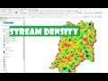 Drainage Stream Density & Drainage frequency of a basin using Arc-Gis.
 Kernel density map using John Snow's Cholera Data in ArcGIS
 Drainage Density Mapping in ArcGIS || ArcGIS 10.2.2 || @GeoTech Studio
 How to find the longest flow path in a River using ArcHydro tool in ArcGis.
 Calculating the volume of Lake-Pond-Reservoir/ Raster using 3D Analyst in Arc-GIS(Arc-map+arc scene)
 Calculating Stream Network Numbers usin ArcGis
 Climate Data (Temperature, Precipitation, Humidity) from 1981-2020
 Deriving River Network & Catchments from a DEM using QGIS
 Drainage or Stream Frequency & Infiltration number calculation in ArcGIS
 how to calculate ls factor of RUSLE
 Flood Risk Simulation Map of an area using ArcGIS
 How to calculate LS FACTOR for USLE/RUSLE in ArcMap
 Create Topographic Profile/Cross Section/Elevation Profile Using ARCGIS Or 3D Analyst extension
 Slope, Aspect, Contour , Hillshade Map in ArcGIS
 How to use a DEM to delineate a Watershed/Basin in ArcGIS