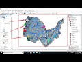
Stream Order from a Digital Elevation Model (DEM) using ArcGIS
Would you like to know which streams have the highest flow accumulations and derive the order of the streams using the Strahler Method with ArcGIS?
This step-by-step tutorial will teach you exactly how to do that. In this tutorial you will learn how to:
1. Derive a stream network using the spatial analyst tools of ArcGIS
2. Use the Raster Calculator to create a new raster with high flow accumulations
3. Derive the order of the streams
4. Export the stream network raster into a network of polylines
⭐NOTE:
‘Kite’ is an excellent tool that can help you boost your productivity when it comes to programming with its free Artificial Intelligence (AI) powered coding assistant. Kite is a plugin which provides smart completions and documentation as you’re typing-in your code, and its compatible with most of the well-known IDEs such as PyCharm, Spyder and VS Code. I absolutely love it, and recommend you guys to try it out as well.
https://www.kite.com/get-kite/?utm_medium=referral&utm_source=youtube&utm_campaign=geodelta&utm_content=description-only
Видео Stream Order from a Digital Elevation Model (DEM) using ArcGIS канала GeoDelta Labs
Показать
Комментарии отсутствуют
Информация о видео
Другие видео канала
 Hydrological modeling in ArcGIS / ArcMap
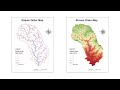 River Stream Order Map in ArcGIS | ArcGIS Tutorial 28
 Slope, Aspect, Contour , Hillshade Map in ArcGIS
 Watershed Delineation in ArcGIS | How to create Drainage Map
 Delineating Multiple Watersheds using Spatial Analyst Tool of ArcGIS
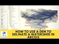 How to use a DEM to delineate a Watershed/Basin in ArcGIS
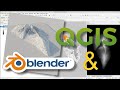 QGIS User 0036 - QGIS and Blender
 Extracting Stream or Drainage Network from DEM in ArcGIS
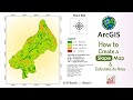 CREATING A SLOPE MAP FROM DIGITAL ELEVATION MODEL (DEM) AND AREA CALCULATION || || Arc Map 10.8 ||
 Stream Order Using ArcGIS (2019)
 Watershed Delineation and Watershed Characteristics in ArcGIS Pro
 Showing DEM in 3D View in ArcGIS || DEM in 3D View in ArcMap || DEM in Arcsene
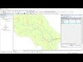 Calculating Stream Network Numbers usin ArcGis
 Stream Order using ArcGIS / Strahler Method - 2019
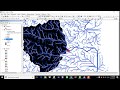 4. Delineate watershed by Pour Point in ArcGis
 Hydrology Tools Map Tutorial – ArcGIS Pro
 Deriving River Network & Catchments from a DEM using QGIS
 Create TIN, DEM and Slope from Contour Line by ArcGIS
 Creating Stream order | Watershed delineation from DEM | Model_Builder | ArcGIS | Part -1