Stream Order using ArcGIS / Strahler Method - 2019
Generate Stream Order from DEM using ArcGIS (2019)
Step 1: Fill Tool - Input -- DEM Data
Step 2: Flow Direction - Input -- Fill Data
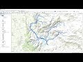
Step 3: Flow Accumulation - Input -- Flow Direction Data
Step 4: Classify -- Flow Direction into 2 types -- color 1st category with -- Blue
Step 5: Map Algebra Tool - Input -- Formula "Flow Accumulation less than 100"
Step 6: Stream Order - Input -- Output from Map Algebra & Flow Direction
Step 7: Stream to Feature - Input -- Output from Stream Order & Flow Direction
Step 8: Data Management Tool -- Generalization -- Use Dissolve Tool (within the tool select "gridcode"
Step 9: Stream Order is Generated -- Classify the data using symbology tool and categories the stream.
Видео Stream Order using ArcGIS / Strahler Method - 2019 канала Terra Spatial
Step 1: Fill Tool - Input -- DEM Data
Step 2: Flow Direction - Input -- Fill Data
Step 3: Flow Accumulation - Input -- Flow Direction Data
Step 4: Classify -- Flow Direction into 2 types -- color 1st category with -- Blue
Step 5: Map Algebra Tool - Input -- Formula "Flow Accumulation less than 100"
Step 6: Stream Order - Input -- Output from Map Algebra & Flow Direction
Step 7: Stream to Feature - Input -- Output from Stream Order & Flow Direction
Step 8: Data Management Tool -- Generalization -- Use Dissolve Tool (within the tool select "gridcode"
Step 9: Stream Order is Generated -- Classify the data using symbology tool and categories the stream.
Видео Stream Order using ArcGIS / Strahler Method - 2019 канала Terra Spatial
Показать
Комментарии отсутствуют
Информация о видео
Другие видео канала
 Stream Order from a Digital Elevation Model (DEM) using ArcGIS
 Topographic Wetness Index (TWI) Calculation in ArcGIS
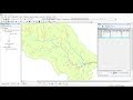 Calculating Stream Network Numbers usin ArcGis
 Mosaicing and Watershed delineation in ARCgis
 Stream Order Using ArcGIS (2019)
 STREAM ORDERING BY STRAHLER METHOD USING ARC MAP 10.3
 Prepare land use and land cover classification in ArcGIS
 How to mosaic DEM in ArcGIS & QGIS
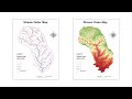 River Stream Order Map in ArcGIS | ArcGIS Tutorial 28
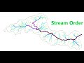 How to Generate Stream Order using ArcGIS
 How to Create 3D Maps with ArcGis and ArcScene!
 ArcGIS Pro: Multiple Ring Buffer - Average Nearest Neighbor - SDE and MC
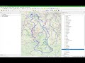 Stream and Catchment Delineation in QGIS 3 using GRASS tools
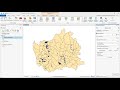 Performing a spatial join in ArcGIS Pro
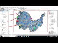 Hydrological modeling in ArcGIS / ArcMap
 Add GPS coordinates into Arcmap
 Delineating Multiple Watersheds using Spatial Analyst Tool of ArcGIS
 How to create river stream order map in ArcGIS | ArcGIS tutorial
 How to clip shapefile on Arcgis
 Create TIN, DEM and Slope from Contour Line by ArcGIS