Stream and Catchment Delineation in QGIS 3 using GRASS tools
This video shows how to delineate streams and a catchment using the GRASS tools from the QGIS processing toolbox. In another video the same was demonstrated using the SAGA tools in QGIS (https://youtu.be/Ro-RRzMMw-c). At the end of this video both methods are compared.
Credits for OpenStreetMap data: © OpenStreetMap contributors
SRTM data available from USGS Earth Explorer: https://earthexplorer.usgs.gov
The procedure is based on Chapter 4 of the book "QGIS for Hydrological Applications - Recipes for Catchment Hydrology and Water Management" by Kurt Menke and Hans van der Kwast. More information about the book can be found at the website of Locate Press: http://www.locatepress.com/hyd
This video is part of IHE Delft OpenCourseWare. More free resources can be found at http://www.gisopencourseware.org
For an overview of our GIS courses and info on tailor made trainings and advise see our folder: https://www.un-ihe.org/sites/default/files/2019_qgis_certification_programme_0.pdf
IHE Delft and Nieuwland Geoinformatie offer an online course. It includes support from experienced trainers and you'll get the official QGIS certificate after completion. More info at: http://www.learning-gis.com
Subscribe to the YouTube Channel for updates!
Видео Stream and Catchment Delineation in QGIS 3 using GRASS tools канала Hans van der Kwast
Показать
Комментарии отсутствуют
Информация о видео
Другие видео канала
 Stream and catchment delineation in QGIS 3
 QGISHydro Webinar 1: Georeferencing and digitizing vectors
 QGISHydro Webinar 4: Stream & Catchment Delineation
 Manual watershed delineation is a five-step process
 Stream and catchment delineation with GIS (theory)
 Google Earth Engine in QGIS - QGIS GEE 01 | burdGIS
 Calculate time of concentration of a river in QGIS (Kirpich)
 Burning stream network into DEM layer in QGIS
 Watershed Delineation using Hydrology Tool in ArcGIS
 Quick & Easy Topographic / Contour Vector Maps For Laser Cutting | How to | Tutorial
 Creating a Soil Map in QGIS # QGIS Tutorial
 QGIS RS Module 01: River Basin Delineation using HydroSHEDS
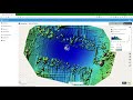 Use WebODM to process drone images and visualise the results in QGIS
 Routing pollution over the flow direction with PCRaster in QGIS
 Create lookup tables from a Raster Attribute Table and reclassify raster using PCRaster in QGIS
 QGISHydro Webinar 5: Adding Open Data to Your Catchment
 Calculate volumes from a DEM in QGIS
 Load spreadsheets in QGIS 3, join and interpolate
 QGISHydro Webinar 7: Map Design