How to Create 3D Maps with ArcGis and ArcScene!
How to create an Image draped on a DEM and on which we added the shadow of the relief
==========================================================
This tutorial shows how to create real 3d modeling of images from Digital Elevation Model ou DEM (SRTM / ALOS ...) with ArcGis / Arscene software.
Topographic map draped over a terrain and to which the shadow of the relief has been added
I Hope you like it, and don't forget to SUBSCRIBE! :)
---------------------------------------------------------------------------------------------------------------
Download DEM (SRTM): https://www.youtube.com/watch?v=0YPFegTcL4w
Or
Download DEM (ALOS): https://www.youtube.com/watch?v=qGN4fhd16rQ
------------------------------------------------------------------------------------------------------------------------------------------
Site web: https://www.saidgis.com/
Facebook: https://web.facebook.com/kaoum.dias
Twitter: https://twitter.com/MouakSiad
linkedin: https://www.linkedin.com/in/said-mouak-4836b414a/
Видео How to Create 3D Maps with ArcGis and ArcScene! канала Said GIS
Показать
Комментарии отсутствуют
Информация о видео
Другие видео канала
 Showing DEM in 3D View in ArcGIS || DEM in 3D View in ArcMap || DEM in Arcsene
 ArcScene 3D Maps
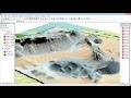 ArcGis 3d analyst Draping an image over a terrain surface
 From Google Maps to 3D Map in Blender- 3D Blender GIS -
 ArcScene 3DFlythrough Video
 Arcgis 3d Analyst Visualizing soil contamination and Edema Rate
 how to visualize aquifer surfaces using ArcGis/ArcScene
 Calculating the Volume of a Raster using 3D Analyst of ArcGIS (ArcMap + ArcScene)
 Arcscene Tutorial
 Garmin Basecamp adding 3D Maps with DEM Digital Elevation Model
 Arcgis 3D analyst/ ArcScene Creating 3D feature or shapefile
 ArcScene Basics
 Create DEM and Slope from elevation contour line with Arcgis 10.4.1
 ArcGIS: Map Georeference using Latitude and Longitude Coordinate System
 How to Create 3D Terrain with Google Maps and Blender!
 Download Ocean Bathymetry (GEBCO 2019)
 Digital Elevation Model (DEM) 3D Visualization in QGIS 3.0
 Insert 3D buildings to Arcscene - 3D binaların Arcscene eklenmesi
 How to Create Map Layout in ArcGIS (From A to Z)
 Introduction to ArcGIS Model Builder