Calculating the Volume of a Raster using 3D Analyst of ArcGIS (ArcMap + ArcScene)
Follow GeoDelta Labs on Facebook - https://www.facebook.com/geodeltalabs/
This tutorial demonstrates to you how to calculate the volume of a specified river cross section using the ArcGIS 3D Analyst tool.
⭐NOTE:
‘Kite’ is an excellent tool that can help you boost your productivity when it comes to programming with its free Artificial Intelligence (AI) powered coding assistant. Kite is a plugin which provides smart completions and documentation as you’re typing-in your code, and its compatible with most of the well-known IDEs such as PyCharm, Spyder and VS Code. I absolutely love it, and recommend you guys to try it out as well.
https://www.kite.com/get-kite/?utm_medium=referral&utm_source=youtube&utm_campaign=geodelta&utm_content=description-only
Видео Calculating the Volume of a Raster using 3D Analyst of ArcGIS (ArcMap + ArcScene) канала GeoDelta Labs
Показать
Комментарии отсутствуют
Информация о видео
Другие видео канала
 Surface Volume of Raster (2D and 3D Area) using 3D Analyst ArcMap and Visualize using ArcScene
 ArcGis 3d Analyst/ ArcScene Animation of flood
 Extracting Elevation Data from Google Earth
 Unsupervised Classification of a satellite image using ArcGIS
 Calculate the volume of lake in ArcGis
 water volume using Arcgis تقدير حجم تخزين المياه من الكنتور
 how to visualize aquifer surfaces using ArcGis/ArcScene
 How to Download Water Bodies from USGS using EarthExplorer (in ESRI Shapefile Format)
 How to Make a Map using QGIS3
 Landsat 8 Image Classification with ArcGIS (Supervised)
 ArcGIS - ArcScene vuelo 3D - Model Builder | Master SIG
 Flood Animation using 3D Analyst tools of ArcGIS (ArcScene + ArcMap)
 How to calculate the volume of reservoir of Dam using ArcGIS
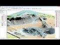 ArcGis 3d analyst Draping an image over a terrain surface
 Stream Order from a Digital Elevation Model (DEM) using ArcGIS
 Groundwater Potential zone Mapping in Arc GIS using Analytic Hierarchy Process (AHP) - Part 1
 Flood Hazard Mapping in GIS-Flood Risk Mapping in ArcGIS
 Extraction du réseau hydrographique et délimitation du bassin versant sur Arcgis
 Advanced Geoprocessing Applications using ArcGIS - Part 1