ArcGis 3d analyst Draping an image over a terrain surface
How to trape an image over a terrain surface usin ArcGis
How to Edit Pdf in Word: https://www.youtube.com/watch?v=0ScbxWv4sGE
To see more videos visit website : https://www.geospatialteam.com/
Видео ArcGis 3d analyst Draping an image over a terrain surface канала Made 4 Geek
How to Edit Pdf in Word: https://www.youtube.com/watch?v=0ScbxWv4sGE
To see more videos visit website : https://www.geospatialteam.com/
Видео ArcGis 3d analyst Draping an image over a terrain surface канала Made 4 Geek
Показать
Комментарии отсутствуют
Информация о видео
Другие видео канала
 How to Create 3D Maps with ArcGis and ArcScene!
 Slope, Aspect, Contour , Hillshade Map in ArcGIS
 How to create a 3D Terrain with Google Maps and height maps in Photoshop - 3D Map Generator Terrain
 how to visualize aquifer surfaces using ArcGis/ArcScene
 Arcgis 3d Analyst Visualizing soil contamination and Edema Rate
 HOW TO CREATE 3D DIGITAL ELEVATION MODEL ON ESRI ARCGIS
 Visualizar el relieve de una imagen satelital en ArcGIS
 Calculating the Volume of a Raster using 3D Analyst of ArcGIS (ArcMap + ArcScene)
 ArcGis ArcScene Displaying terrain surfaces in 3D
 ArcGIS - ArcScene vuelo 3D - Model Builder | Master SIG
 3D Visualization of a DEM in ArcGIS Pro
 3D GIS: 3D Analysis Tools and Visualization with ArcGIS
 ArcGis: Download Open Street Map data in Vector format
 Developing a 3D Model using QGIS
 ArcMap Surface Tools( Contour, Aspect, Slope, Hillshade)
 How to use a DEM to delineate a Watershed/Basin in ArcGIS
 A Complete Beginner's Guide to ArcGIS Desktop (Part 1)
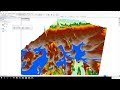 Flood Animation using 3D Analyst tools of ArcGIS (ArcScene + ArcMap)
 ArcScene Basics