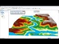
Arcgis 3D analyst/ ArcScene Creating 3D feature or shapefile
How to edit or create a shapefile with ArcScene, and define it Z-values.
Features with 3d geometry are automatically displayed in 3d in a scene using the Z-values from the feature geometry.
To see more videos visit website : http://monde-geospatial.com/
Видео Arcgis 3D analyst/ ArcScene Creating 3D feature or shapefile канала Made 4 Geek
Features with 3d geometry are automatically displayed in 3d in a scene using the Z-values from the feature geometry.
To see more videos visit website : http://monde-geospatial.com/
Видео Arcgis 3D analyst/ ArcScene Creating 3D feature or shapefile канала Made 4 Geek
Показать
Комментарии отсутствуют
Информация о видео
Другие видео канала
 how to visualize aquifer surfaces using ArcGis/ArcScene
 3D GIS: 3D Analysis Tools and Visualization with ArcGIS
 QGIS Quick Tip - Custom outline and dropshadow
 How to do Dissolve / Union / Intersect / Merge in Arc GIS (Geo processing)
 ArcGis 3d Analyst/ ArcScene Animation of flood
 Altering Shapefile Structure Selecting and Deleting Features
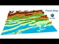 Flood Risk Simulation Map of an area using ArcGIS
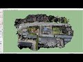 How to create 3D environment models from drone images
 3D Analysis in ArcGIS / ArcScene
 How to Create 3D Maps with ArcGis and ArcScene!
 créer TIN et MNT et l'ouvrent en Arc Scène arcgis
 Module 6: How to Perform a Viewshed Analysis in ArcGIS for Desktop
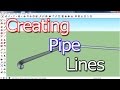 How To Create Pipe lines in Sketchup
 How to create 3D model in Arc Scene
 Styling of streams, catchment and flow direction in QGIS
 Creating Road Polygons from Lines - Using the Buffer Tool in ArcGIS Pro
 Study Area Mapping | Create Map Layout in ArcGIS
 Showing DEM in 3D View in ArcGIS || DEM in 3D View in ArcMap || DEM in Arcsene
 Landsat 8 Image Classification with ArcGIS (Supervised)