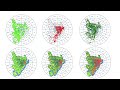
Flood Risk Simulation Map of an area using ArcGIS
How to prepare flood inundation simulation of an area using ArcMap and Arcscene. Hope this will make you understand potential flooding area identification within very short time using digital elevation model (DEM). I hope you will enjoy this video.
Tags: how to prepare flood map, flood risk map, flood inundation map, flood simulation, flood risk identification, how to prepare flood map in arcgis
#flood_map #flood_simulation #flood_risk_map #DEM #gisrssolution
Видео Flood Risk Simulation Map of an area using ArcGIS канала GIS & RS Solution
Tags: how to prepare flood map, flood risk map, flood inundation map, flood simulation, flood risk identification, how to prepare flood map in arcgis
#flood_map #flood_simulation #flood_risk_map #DEM #gisrssolution
Видео Flood Risk Simulation Map of an area using ArcGIS канала GIS & RS Solution
Показать
Комментарии отсутствуют
Информация о видео
Другие видео канала
 Estimation of any Land Classes from LULC Map Based on the Gradient Direction & Distances | Part 2
 How to Solve ArcGIS Error 999999
 Clipping/Extracting Raster Data without Using any Shapefile in ArcGIS
 Download Weather & Climate Data
 How to Download Digital Surface Model (DSM) !! Which is best DSM or DEM?
 How to Create YouTube, Facebook, Gmail Shortcut on Desktop
 Mapping Ecosystem Service Value (ESV) using ArcGIS
 Extract Elevation Values from DEM
 Risk Assessment (Fire, Explosion, Flammable, Toxic Gas dispersion) of an Industry Using ALOHA
 Download Tidal Data for any Location
 Estimation of Urban Areas Based on the Gradient Direction & Distances & Urban sprawl mapping |Part 1
 A Complete Tutorial on Making Wind Rose Diagram (Software Download, Installation & Diagram Creation)
 How to Remove No Data/Black Background from Raster Images
 Adding Google Earth Satellite Image/Google Maps and Work Faster in ArcGIS
 Area, Perimeter, Calculate Geometry Tool Disabled Problem Solved in ArcGIS
 Download Hourly Precipitation, Temp, Cloud Cover, Humidity, Wind speed, direction from 1940-Present
 How to Download Daily Precipitation and Temperature Data (1955 to 2024) from NOAA
 GIS Day 2023
 Download GIS & Remote Sensing Book for Free
 How to Covert Image to Text/Word Document
 How to Draw Automatic Duplicate Line in ArcGIS