How to find the longest flow path in a River using ArcHydro tool in ArcGis.
https://t.me/joinchat/LBeSHB0v6sZn_PdX06tXxw
Join me in telegram
Видео How to find the longest flow path in a River using ArcHydro tool in ArcGis. канала The Structural Er.Ranjeet
Join me in telegram
Видео How to find the longest flow path in a River using ArcHydro tool in ArcGis. канала The Structural Er.Ranjeet
Показать
Комментарии отсутствуют
Информация о видео
6 августа 2020 г. 19:14:24
00:09:37
Другие видео канала
 Watershed Delineation for Morphometric Analysis in Arc GIS
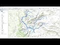 Stream Order from a Digital Elevation Model (DEM) using ArcGIS
 Part 6 || ARC Gis || length of Longest Stream
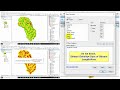 How to Calculate Stream or drainage Length and Density in ArcGIS
 How to calculate area of the polygon and length of the streams|| Summary Statistics in ArcGIS
 How to Convert Google Earth KMZ file to Shapefile (Quick and Easy)
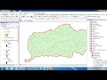 Watershed Delineation using Hydrology Tool in ArcGIS
 ESRI ArcGIS Creating Polyline Shp File
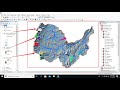 Hydrological modeling in ArcGIS / ArcMap
 Stream Order Using ArcGIS (2019)
 Arc Hydro in ArcGIS Pro
 Video5: Longest Flow Path and Slope Calculation within a Watershed Using ArcGIS
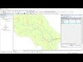 Calculating Stream Network Numbers usin ArcGis
 CARA MEMBUAT PETA DAS DENGAN ARCGIS
 Watershed Delineation using Arc Hydro Tools
 How To Make Study Area Map in ArcGIS. Complete Process. #arcgis #studyareamap #civilengineering
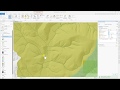 Hydrology Tools Map Tutorial – ArcGIS Pro
 Watershed Delineation and Watershed Characteristics in ArcGIS Pro
 Catchment area Calculation using arcgis 10.4 : watershed delineation
 Length and width calculation of polygons using ArcGIS