ARCGIS : How to calculate area, length, and other geometric properties?
The Calculate Geometry tool allows you to access the geometry of the features in a layer. The tool can calculate coordinate values, lengths, and areas, depending on the geometry of the input layer.
Designing Better Maps: A Guide for GIS Users
https://goo.gl/YyxQeo
Getting to Know ArcGIS
https://goo.gl/yLJvBG
Видео ARCGIS : How to calculate area, length, and other geometric properties? канала geomatika
Designing Better Maps: A Guide for GIS Users
https://goo.gl/YyxQeo
Getting to Know ArcGIS
https://goo.gl/yLJvBG
Видео ARCGIS : How to calculate area, length, and other geometric properties? канала geomatika
Показать
Комментарии отсутствуют
Информация о видео
Другие видео канала
 How to calculate area, perimeter and lengh in ArcGis
 Length and width calculation of polygons using ArcGIS
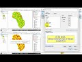 How to Calculate Stream or drainage Length and Density in ArcGIS
 How to calculate area in ArcGIS from attribute table
 How to Create and Edit Shapefiles in Arc GIS
 Prediction of Land Use/Land Cover Change using QGIS and ArcGIS (2010-2020-2030)
 A Complete Beginner's Guide to ArcGIS Desktop (Part 1)
 Area calculation from NDVI
 How to Calculate Tc On GIS Part Two
 Watershed Delineation for Morphometric Analysis in Arc GIS
 ArcGIS learning | Calculate Length of River and save output data in pdf
 How to process area calculate from land use and land cover (LULC) in Arc Gis 10.5
 How to calculate length in Arcgis using ArcMap 10.2
 River Stream Order Map in ArcGIS | ArcGIS Tutorial 28
 How to find the longest flow path in a River using ArcHydro tool in ArcGis.
 How to calculate distance to streams and Roads in ArcGIS.
 Extract digital elevation model from Google Earth | Extract digital elevation model
 Map Document Properties Store Relative Pathnames to data sources | a GIS Video by Gregory Lund
 Tutorial N°9 : Hypsometric map using ArcGIS / Carte hypsometrique sous Arcgis
 Calculating Area of Polygons using ArcGIS