Pre-Thanksgiving Forecast with Possible Rain Monday
Hazy sunshine and seasonal highs, again today. An upper level ridge of high pressure starts to build today. This will usher in warmer temps Thanksgiving Day into Black Friday. Highs will return to the low 70s. We haven't been there since November 1st! However... before we do there is still cold air aloft this morning. A Freeze WARNING issued for the San Joaquin Valley through 8 AM for areas north of Bakersfield into the the Fresno area. Morning temps range from 27-32. Mountain and desert areas will also see that this morning. Afternoon highs stay in the low to mid 60s across the county. Remember... the warm up is tomorrow. The stable air overhead creates our air quality to stay in the hazy range; unhealthy for sensitive groups. This will run through Saturday.
Our warm up and haze won't last forever as a minor short wave, low pressure system makes its way into the state late Saturday into Sunday. Temps fall back to seasonal highs and breezy conditions across the region. The winds will help improve some of our bad air. Mountain areas will see highs fall back to the 50s. Then we look forward to next Monday afternoon into Tuesday.
Models are illustrating two separate storm systems. The first comes to town late Monday into Tuesday. It should involve a rain shadow with southerly winds out ahead of the system, followed by meaningful rainfall. I'm expecting .15-.50" in the South Valley, with the least rainfall in far south areas affected by the rain shadow. Mountain towns will see rain turn to snow at about the 5,500' level. Winds will shift to the northwest late Monday into Tuesday with showers through Tuesday morning. Snow levels will fall to about 4,000'. Snowfall of 3-6" is expected above 4,500' at this time, but that forecast may well change as the weather system finally comes into focus. It is important for you to realize that what will become Monday's storm is currently a wave in Asia. A lot of modification will take place with that wave between now and 6 days from now. Most global models have increased their expectation for precipitation while a few (the German and Japanese models) are predicting the system to blow by California to the east. It is too early to make any plans based upon what we see right now. I would say a much better idea of how that wave over Asia will manifest itself can be expected by about Friday.
***SIDE NOTE*** The latest American model now suggests that Monday & Tuesday's system may push just north of us. This means maybe no rain at all, but cooler air will still arrive. One again... we will have a better view of this late Friday.
Models also suggest a second storm will develop by Thursday and Friday with another good dose of precipitation and snow levels down to about the passes. Today our rain year precipitation dropped to 97% of normal, below 100% for the first time since the Election Day storm. I am confident that next week will boost Bakersfield back up to above normal precipitation. November is already wetter than normal and a good rain for the first two days of December will be most welcomed. So, enjoy the lovely Thanksgiving Day weather and the weekend, then enjoy some rain from the heavens next week.
Aaron Perlman gives the local weather forecast on KBAK / KBFX Eyewitness News every Monday - Friday from 4:30-9 AM. You can catch up at Bakersfieldnow.com.
Видео Pre-Thanksgiving Forecast with Possible Rain Monday канала Aaron Perlman
Показать
Комментарии отсутствуют
Информация о видео
Другие видео канала
 HEAT ADVISORY - One More Day!
 Heat Advisory Coming (Tuesday - Thursday)
 Star Wars Forecast - How Many Star Wars References Can You County
 It's Your Birthday
 Weatherman VS Spider #acrossthespiderverse #weather #spider
 HOUCHIN HEARTBEATS: Houchin Blood Bank's First Student Spokesperson Hallie Keese
 Free Comic Book Day Rap: The Sequel preview
 WebMD Chief Medical Dr. Explains Says Heart Disease Affects Black Americans More
 Return Of The Jedi Producer, Howard Kazanjian, Talks 40 Year Anniversary
 WEEKEND FORECAST - Hanukkah and Christmas Week Turns Mild; 60s. Fog Possible. (December 12, 2022)
 Hiking the John Muir Trail 2021 - Day 9: Mather Pass to Le Conte Canyon
 Winter Ends & Spring Begins (Weather Forecast)
 Christmas Night
 Weekend Forecast Brings 70s & Rain for the Kern Mountains (October 5th, 2018)
 "Atmospheric River" - Flood Watch & Winter Storm Warning
 Weatherman Tries the "Elaine Dance" from Seinfeld
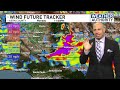 Windy and Chilly Monday / Rain Returns Thursday Night (Monday, November 28th, 2022)
 Don't Expect Triple Digits For A While
 Hiking the John Muir Trail 2021 - Day 5: Tyndall Creek to Onion Valley
 Congressman Kevin McCarthy Gives The Forecast