Landsat 8: Band by Band
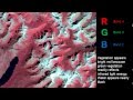
The Landsat 8 satellite doesn't take pictures like a camera, but rather takes pictures of the Earth using different wavelengths of light. Each of these different 'bands' can then be reassembled to tell us different stories about Earth.
Landsat satellites circle the globe every 99 minutes, collecting data about the land surfaces passing underneath. After 16 days, the Landsat satellite has passed over every spot on the globe, and recorded data in 11 different wavelength regions. The individual wavelength bands can be combined to create color images, with different combinations of the 11 bands revealing different information about the condition of the land cover.
The data for this video was collected by Landsat 5 on November 10, 2011.
Visualizer: Alex Kekesi (lead)
For more information or to download this public domain video, go to https://svs.gsfc.nasa.gov/11491#18835.
Видео Landsat 8: Band by Band канала NASA Scientific Visualization Studio
Показать
Комментарии отсутствуют
Информация о видео
17 декабря 2016 г. 2:59:04
00:02:57
Другие видео канала
 Remote Sensing - Band Combinations
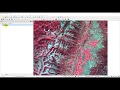 Download Landsat 8 Data for Free
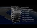 NASA | Peeling Back Landsat's Layers of Data
 Landsat 8 Image Classification with ArcGIS (Supervised)
 Download very high resolution satellite image 0.3 metre for free
 What Huygens Saw On Titan - New Image Processing
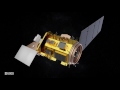 Anatomy of Landsat 8
 Downloading Landsat 8 satellite image data to use in a GIS
 Landsat 9: Continuing the Legacy Promo
 Mapping the Invisible: Introduction to Spectral Remote Sensing
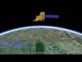 A Planetary Perspective: With Landsat and Google Earth Engine
 Landcover Change Detection using Landsat 8 (Australian Forest Fires 2019-2020)
 Remote Sensing Basics
 How to Pull Images from Satellites in Orbit (NOAA 15,18,19 and METEOR M2)
 Salient characteristics of Landsat, IRS, Cartosat, Resourcesat sensors
 NASA | Landsat's Orbit
 Satellite Frequency Bands
 Landsat 8 Swath Animation
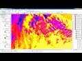 Calculating Land Surface Temperature Landsat8 by ArcGIS