Mapping the Invisible: Introduction to Spectral Remote Sensing
Did you ever wonder how your camera actually takes a picture? It's all about light - it records the light that objects reflect. This video explores the basic principles used by optical sensors like Landsat, AVIRIS, and other remote sensing sensors to record the things that we can't see with our eyes - like the health of plants on the ground. It explains the basic principles of the electromagnetic spectrum, bands and spectral resolution in data and the uses of spectral data to answer science questions.
Suggested citation for this video: National Ecological Observatory Network. March 19, 2015. Mapping the Invisible: Introduction to Spectral Remote Sensing [Video file]. Courtesy: Battelle. Retrieved from https://youtu.be/3iaFzafWJQE.
Видео Mapping the Invisible: Introduction to Spectral Remote Sensing канала NEON Science
Показать
Комментарии отсутствуют
Информация о видео
Другие видео канала
 Introduction to Hyperspectral Remote Sensing: A Presentation
 How Does LiDAR Remote Sensing Work? Light Detection and Ranging
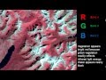 Remote Sensing - Band Combinations
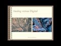 Remote Sensing Basics
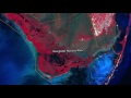 Landsat 8: Band by Band
 The Importance of Accurate Coastal Elevation and Shoreline Data
 What Is Multispectral Imaging? – Vision Campus
 LiDAR - Introduction to Light Detection and Ranging
 From Pixels to Products: An Overview of Satellite Remote Sensing
 Turbos: How They Work | Science Garage
 NASA ARSET: Fundamentals of Aquatic Remote Sensing
 GOCE: Geoid
 DJI | NCDOT – Building a Statewide Drone Program
 Daniele Quercia: Happy maps
 Multispectral Imaging Explained
 Hyperspectral remote sensing and its applications
 The Rare-Earth Elements That Will Change Our Future | Treasure Hunters | Spark
 WEBINAR - Hyperspectral Analysis of Vegetation with an NIR spectroradiometer
 What is Airborne Hyperspectral Imaging?
 Introduction to Spectral (Un)mixing (Class 6 - v1)