GOCE: Geoid
Launched on 17 March 2009, ESA's Gravity field and steady-state Ocean Circulation Explorer (GOCE) is bringing about a whole new level of understanding of one of Earth's most fundamental forces of nature: the gravity field. Dubbed the 'Formula 1' of satellites, GOCE is mapping Earth's gravity field in unprecedented detail.
This has given rise to a unique model of the 'geoid', which is the surface of an hypothetical global ocean in the absence of tides and currents, shaped only by gravity. It is a crucial reference for measuring ocean circulation and sea-level change, which are affected by climate change.
The colours in the image represent deviations in height ( -100 m to + 100 m) from an ideal geoid. The blue colours represent low values and the reds/yellows represent high values.
See also: Earth's gravity revealed in unprecedented detail at: http://www.esa.int/esaCP/SEM1AK6UPLG_index_0.html
Видео GOCE: Geoid канала European Space Agency, ESA
Показать
Комментарии отсутствуют
Информация о видео
28 апреля 2011 г. 16:01:43
00:04:34
Другие видео канала
 What is Sea Level?
 Shape of the Earth
 Coordinate System Jargon: geoid, datum, projection
 Spheroids, Ellipsoid, and Geoid - GIS Fundamentals and Mapping (4)
 Earth from Space: Fairbanks, Alaska
 Gravity's grip on earth
 The Solar System Is Not Like You Think It Is
 Sneak Peek of NASA's GRACE Twins (media briefing)
 पृथ्वी की आकृति कैसी है ? | Shape of Earth | Angaraland and Gondwanaland | Geoid Shape of Earth
 TIMELAPSE OF THE FUTURE: A Journey to the End of Time (4K)
 EARTH FROM SPACE: Like You've Never Seen Before
 Earth from Space: Kainji Lake, Nigeria
 LE CHAMP DE PESANTEUR TERRESTRE
 15 Facts About Earth Sound Too Bizarre to Be True
 Ist die Erde wirklich rund? | Harald Lesch
 Webb launch campaign highlights
 Ellipsoids and geoid
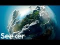 No Human Has Ever Left Earth’s Atmosphere, Here's Why
 Earth from Space: White Nile, Sudan
 ‘Dark side’ of moon seen from surface for first time