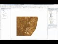
Landsat 8: Estimating Land Surface Temperature Using ArcGIS
This video walks through the conversion of Landsat 8 thermal bands to estimate both at sattellite land surface temperature.
Видео Landsat 8: Estimating Land Surface Temperature Using ArcGIS канала Usman Buhari
Видео Landsat 8: Estimating Land Surface Temperature Using ArcGIS канала Usman Buhari
Показать
Комментарии отсутствуют
Информация о видео
Другие видео канала
 Landsat 8: Atmospheric Correction and Band Rationing Using ArcGIS
 How To Calculating Land Surface Temperature Using Landsat 8
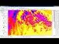 Calculating Land Surface Temperature Landsat8 by ArcGIS
 Supervised Image Classification in ArcGIS Desktop - ArcMap
 Understanding Coordinate Systems and Projections for ArcGIS
 Urban Heat Island (UHI) and Urban Thermal Field Variance Index (UTFVI) MODEL Using ArcGIS Software
 Getting Started with MODIS Land Surface Temperature Data- (Part 1)
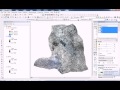 ArcMap 10.2: Landsat Band Composite and NDVI Calculation
 ArcGIS Apps: ArcGIS Pro: An Introduction
 How to Download Daily Soil Water Index from Copernicus Global Land Service
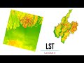 Estimating Land Surface Temperature Landsat 8 | ArcGIS Tutorial | 2020
 RS6.7 - Soil moisture remote sensing
 ArcGIS Pro: Migrating from ArcMap
 Land surface Temperature from Landsat 8 using ArcMap GIS
 watershed delineation from DEM by ModelBuilder in ArcGis
 Land Surface Temperature (LST) Data Extraction From Sentinel-3 SLSTR Level 2 Data using ESA SNAP
 Delineation of Groundwater Potential Zones Using GIS/Remote sensing Techniques and AHP
 Forest cover change or NDVI calculation in Landset 8 using arc map 10.2
 Landsat 8 Image Classification with ArcGIS (Supervised)