Download Sentinel-2 Imagery (10m resolution) for Free
Hi GIS & RS Learners,
Welcome to GIS and RS Solution channel. I hope you are doing very great at your place. Today I am bringing a new brand-new video on how to download 10 meter very high-resolution sentinel 2 image of any location for free. Expecting you will find this tutorial is the easiest way to download 10-meter sentinel-2 image.
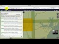
Link: https://scihub.copernicus.eu/dhus/#/home
Sentinel-2 will serve a wide range of applications related to Earth's land and coastal water.
• Monitoring land cover change for environmental monitoring
• Agricultural applications, such as crop monitoring and management to help food security
• Detailed vegetation and forest monitoring and parameter generation (e.g. leaf area index, chlorophyll concentration, carbon mass estimations)
• Observation of coastal zones (marine environmental monitoring, coastal zone mapping)
• Inland water monitoring
• Glacier monitoring, ice extent mapping, snow cover monitoring
• Flood mapping & management (risk analysis, loss assessment, disaster management during floods)
• Lava flow mapping
Well, you can SUBSCRIBE this channel and press the bell icon so that you can get every new video notification.
Видео Download Sentinel-2 Imagery (10m resolution) for Free канала GIS & RS Solution
Welcome to GIS and RS Solution channel. I hope you are doing very great at your place. Today I am bringing a new brand-new video on how to download 10 meter very high-resolution sentinel 2 image of any location for free. Expecting you will find this tutorial is the easiest way to download 10-meter sentinel-2 image.
Link: https://scihub.copernicus.eu/dhus/#/home
Sentinel-2 will serve a wide range of applications related to Earth's land and coastal water.
• Monitoring land cover change for environmental monitoring
• Agricultural applications, such as crop monitoring and management to help food security
• Detailed vegetation and forest monitoring and parameter generation (e.g. leaf area index, chlorophyll concentration, carbon mass estimations)
• Observation of coastal zones (marine environmental monitoring, coastal zone mapping)
• Inland water monitoring
• Glacier monitoring, ice extent mapping, snow cover monitoring
• Flood mapping & management (risk analysis, loss assessment, disaster management during floods)
• Lava flow mapping
Well, you can SUBSCRIBE this channel and press the bell icon so that you can get every new video notification.
Видео Download Sentinel-2 Imagery (10m resolution) for Free канала GIS & RS Solution
Показать
Комментарии отсутствуют
Информация о видео
Другие видео канала
 Downloading Sentinel Imagery Via Copernicus Open Access Hub
 Free LULC @ 10m Resoultion provided by ESRI using Sentinel-2 | Download for any Region
 Calculate NDVI from Sentinel 2 and reclassify in QGIS
 Downloading and preprocessing Sentinel 2 images using the Semi-Classification Plugin in QGIS 3.0
 How to download Sentinel-2 imagery in QGIS
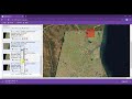 Download Sentinel 2 Imagery - 10 m Resolution using EarthExplorer (USGS)
 OSINT At Home #9 – My Top 4 Free Satellite Imagery Sources
 Download very high resolution satellite image 0.3 metre for free
 Sentinel 2 natural image data processing
 how to Download Sentinel 2 Datasets 2020 for Free
 ESA Echoes in Space - Geometry: Sentinel-1 Data Access
 Download Sentinel-2 Imagery for Free (10 meter resolution)
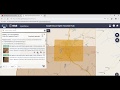 How to Download Sentinel-2 Level-2A Satellite Imagery from Copernicus Open Access Hub
 How to Download Free Geo-Reference High Resolution Satellite imageries (2 meter) from SAS Planet
 Sentinel-2: an introduction
 Download Geological ,Geomorphological,soil and land use map in .shp(Shape file) of India for free
 Download Rainfall data from CHRS and using .shp file, watershed, and location, etc.
 How To Download Sentinel-2 Satellite Imagery (10M Resolution) || Geographic Information System
 Using the EO browser to download sentinel 2 data