- Популярные видео
- Авто
- Видео-блоги
- ДТП, аварии
- Для маленьких
- Еда, напитки
- Животные
- Закон и право
- Знаменитости
- Игры
- Искусство
- Комедии
- Красота, мода
- Кулинария, рецепты
- Люди
- Мото
- Музыка
- Мультфильмы
- Наука, технологии
- Новости
- Образование
- Политика
- Праздники
- Приколы
- Природа
- Происшествия
- Путешествия
- Развлечения
- Ржач
- Семья
- Сериалы
- Спорт
- Стиль жизни
- ТВ передачи
- Танцы
- Технологии
- Товары
- Ужасы
- Фильмы
- Шоу-бизнес
- Юмор
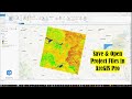
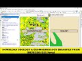
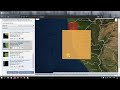
Free LULC @ 10m Resoultion provided by ESRI using Sentinel-2 | Download for any Region
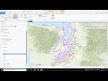
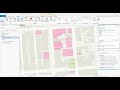
This video is for downloading Landuse/Landcover (LULC) data with 10m
Resolution, avialabe for entire world. Free LULC Data for the year
2020 using ESA Sentinel-2. ESRI uses the deep learning method to classify
the LULC using the following bands visible blue, green, red, near infrared,
and two shortwave infrared bands. Following LULC classes are avaiable
Water, Trees, Grass, Flooded Vegetation, Crops, Scrub or Shrub, Built Area,
Bare Ground, Snow or Ice and Clouds (No land cover information due to
persistent cloud cover).@GISMadras
WEB Link:
Website for information:
https://www.arcgis.com/home/item.html?id=d6642f8a4f6d4685a24ae2dc0c73d4ac
Application for Downloading (Website)
https://www.arcgis.com/apps/instant/media/index.html?appid=fc92d38533d440078f17678ebc20e8e2
00:00 Offical Website
00:33 Overview of the LULC Data
02:52 Downloading LULC Data
04:26 Visualizing LULC in QGIS
06:07 Thanks for Watching - GIS Madras
Видео Free LULC @ 10m Resoultion provided by ESRI using Sentinel-2 | Download for any Region канала GIS Madras
Комментарии отсутствуют
Информация о видео
19 июля 2021 г. 17:30:02
00:06:14
Другие видео канала