How to Select the Best Imagery for Your Remote Sensing Project
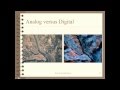
Do you need to understand how to choose a remote sensing approach for your work? This webinar will prepare you to select the best imagery to meet the needs and objectives of your next project. Advantages and disadvantages of digital vs. analog imagery will be discussed. The characteristics common to all imagery will be presented, defined, and examples provided. The final selection of the best imagery is always determined by balancing these characteristics with cost. The webinar will conclude with a discussion of these tradeoffs and costs of imagery. Russ Congalton of UNH Presents.
Видео How to Select the Best Imagery for Your Remote Sensing Project канала VTgeospatial
Видео How to Select the Best Imagery for Your Remote Sensing Project канала VTgeospatial
Показать
Комментарии отсутствуют
Информация о видео
Другие видео канала
 Remote Sensing Basics
 DIY Remote Sensing
 Image Analysis using NDVI to Assess Vegetation Greenness (iGETT-Remote Sensing)
 The Democratization of Remote Sensing
 Landsat 8: Band by Band
 NASA ARSET: Basics of Synthetic Aperture Radar (SAR), Session 1/4
 Mapping the Invisible: Introduction to Spectral Remote Sensing
 NASA ARSET: Surface Water Budget Estimation Based on Remote Sensing, Session 4/4
 Hyperspectral Imaging: Beyond Limitations of Human Color Vision | Dr. Narine Sarvazyan | TEDxYSMU
 NASA ARSET: Remote Sensing for Conservation, Session 1/2
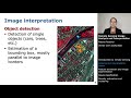 Remote Sensing Image Analysis and Interpretation: Image analysis and interpretation basics
 Webinar 2.1: Remote Sensing Introduction and Characteristics of Satellite Data
 What is Spatial Resolution in Remote Sensing?
 Introduction to Hyperspectral Remote Sensing
 Hyperspectral remote sensing and its applications
 Color Theory for Remote Sensing - What is Remote Sensing? (6/9)
 Geog136 Lecture 11.1 Remote sensing basics
 Remote Sensing Image Analysis and Interpretation: Introduction to Remote Sensing
 Automated Object Based Image Feature Extraction
 NASA ARSET: Overview of Agricultural Remote Sensing, Part 1/4