NASA ARSET: Surface Water Budget Estimation Based on Remote Sensing, Session 4/4
Introductory Webinar: Using Earth Observations to Monitor Water Budgets for River Basin Management
Session Four: The final session will include a review of remote sensing data sources for surface water budget components, and run through estimating a water budget of a watershed using remote sensing components.
Download materials from this presentation: https://arset.gsfc.nasa.gov/water/web...
This training was created by NASA's Applied Remote Sensing Training Program (ARSET). ARSET is a part of NASA's Applied Science's Capacity Building Program. Learn more about ARSET: http://arset.gsfc.nasa.gov/
Видео NASA ARSET: Surface Water Budget Estimation Based on Remote Sensing, Session 4/4 канала NASA Video
Показать
Комментарии отсутствуют
Информация о видео
Другие видео канала
 NASA ARSET: Interferometric SAR for Landslide Observations, Part 2/3
 NASA ARSET: Remote Sensing-Based Drought Monitoring, Session 1/2
 31 Oct 2019 Remote Sensing Applications in Agriculture Crop Inventory & Yield Forecasting
 SATELLITE-BASED EVAPOTRANSPIRATION FOR CROP WATER USE MAPPING AND DROUGHT MONITORING
 NASA ARSET: Access of Earth Observations and Modeled Data for River Basin Monitoring, Part 1/3
 Integrated applications of RS and GIS in groundwater studies
 NASA ARSET: Hyperspectral Data for Coastal and Ocean Systems, Part 3/3
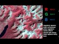 Remote Sensing - Band Combinations
 NASA ARSET: Overview of Hyperspectral Data, Part 1/3
 NASA ARSET: Satellites, Sensors, and Earth Systems Models for Water Resources Management
 The story of 'Oumuamua, the first visitor from another star system | Karen J. Meech
 RUS webinar: Freshwater Quality Monitoring with Sentinel-2 - HYDR02
 Introduction to Hyperspectral Remote Sensing
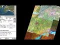 Landsat Sensors
 RS6.7 - Soil moisture remote sensing
 Introduction to Hyperspectral Remote Sensing: A Presentation
 Soyuz undocking, reentry and landing explained
 NASA ARSET: Monitoring Flood Extent with Google Earth Engine, Part 1/2
 NASA ARSET: Basics of Synthetic Aperture Radar (SAR), Session 1/4