download DEM from USGS Server
DEM download form earth explorer server. to download, you have to register first. they use your login ID to search for your location area. Follow the steps shown in video.
We will see
How to download DEM from USGS Server
Go to https://earthexplorer.usgs.gov/
Register First......
Then Login
Login completed
Now, follow the steps
any option u can use for searching the area
you want, kml/shp/coordinates or
simply by writing
the location
Zoom in
Take 4-5 points which will cover your AOI
Selection completed, now, go for Dataset
Digital Elevation
SRTM-SRTm 1 Arc......
Go for Results
Result will show, some of the file they found
you need to check, whether the image covers your AOI, If matches, download it as GEOTIFF format
Download completed.
open it in ArcMap
Thanks for Watching
Like, Subscribe and Share
for more videos on Excel and ArcGIS
#How_to #DEM #USGS #GIS_Tutorial
Related tags: free download satellite images, landsat 8 image download, download landsat 8 images, download satellite images, usgs satellite images download, download usgs satellite images, how to download any satellite images, download high resolution images earth explorer, download high resolution satellite images, interferometry,gis, earth explorer, shapefile, download, water bodies, arcgis, earth explorer tutorial, shuttle radar topographic mission, erdas, geomatica
Видео download DEM from USGS Server канала GIS Tutorial
Показать
Комментарии отсутствуют
Информация о видео
Другие видео канала
 An Absolute Beginner's Guide to QGIS 3
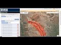 How to Download Water Bodies from USGS using EarthExplorer (in ESRI Shapefile Format)
 How to create DEM in ArcMap
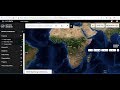 How to Download ASTER DEM 30m Data for FREE
 Download Free Elevation Data (DEM) from the USGS National Map and NRCS Geospatial Data Gateway
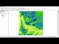 Watershed Delineation using ArcGIS from DEM - Simple and Straightforward
 Downloading a Digital Elevation Model (NASA) from NASA EarthData –Tutorial
 Download Digital Elevation Model DEM 12.5 meters
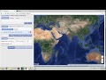 Downloading satellite data from USGS websites
 How to use a DEM to delineate a Watershed/Basin in ArcGIS
 How to create Slope Map from Dem file in ArcGis 10.5 (Nepali) with English Subtitle
 Custom Shapefile Creation on ArcMap
 Downloading DEM from Earth Explorer | Stitching DEM Mosaics | Extract DEM by Mask
 Arcgis : Merge the raster datasets /fusionner raster arcgis /Mosaic raster dataset ArcGIS
 Extracting Elevation Data from Google Earth
 Deriving River Network & Catchments from a DEM using QGIS
 Registration Procedure for Earth Explorer USGS website
 How to Download the Latest Land Use Land Cover (LULC) Data.
 How to extract contour lines And DEM from Google Earth
 Stream Order from a Digital Elevation Model (DEM) using ArcGIS