Image Classification Map Tutorial - ArcGIS Pro
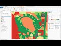
In this demonstration tutorial, we use the Classification Tools in ArcGIS Pro to perform a Maximum Likelihood spectral analysis of NAIP imagery. We go over defining training samples and classifying the land cover on a local golf course, in order to measure the acres of grass for a fertilizer treatment. The instructions are posted below and the data can be downloaded from the web. If you find this video helpful, please like it and subscribe. Thanks!
Instructions: https://drive.google.com/open?id=1nSIrf2NW0cjOozuk1xoKDyhS2ZrNtbe_
Видео Image Classification Map Tutorial - ArcGIS Pro канала MapPractical
Instructions: https://drive.google.com/open?id=1nSIrf2NW0cjOozuk1xoKDyhS2ZrNtbe_
Видео Image Classification Map Tutorial - ArcGIS Pro канала MapPractical
Показать
Комментарии отсутствуют
Информация о видео
Другие видео канала
 ArcGIS Pro: Machine Learning Classification for Impervious Surfaces
 Image Classification Demo
 Georeferencing an Image in ArcGIS Pro
 Land Cover Classification using the Semi-Automatic Classification Plugin version 7
 Beyond Where: Modeling Spatial Relationships and Making Predictions
 Model Builder Map Tutorial – Arc GIS Pro
 Automated Object Based Image Feature Extraction
 arcgis iso, principal components, NDVI, NDBI, NDBI, NDWI
 Landuse classification of Sentinel 2A, L-8 & L-7 image in ArcGIS | A complete guide on LULC
 Lecture 7 - Advanced Cartography – Raster Shaded Relief
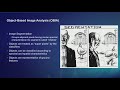 ArcGIS Pro: Image Segmentation, Classification and Machine Learning
 3D Profiling and Layout in ArcGIS Pro
 Working with Landsat imagery in ArcGIS Pro
 Calculating Land Surface Temperature Landsat8 by ArcGIS
 How to Create 3D Maps with ArcGis and ArcScene!
 OTB QGIS Machine Learning Overview 2018 0126
 Satellite Imagery Cloud Removal and Correction In ArcGIS Pro
 Landsat 8 Image Classification with ArcGIS (Supervised)
 Supervised classification in Google Earth Engine
 GeoAI - Pixel Based Classification using Modern Machine Learning techniques in ArcGIS