ArcGIS Pro: Image Segmentation, Classification and Machine Learning
Extracting information from remotely sensed imagery is an important step to providing timely information for your GIS. ArcGIS Pro desktop provides a rich environment to process and exploit imagery. A significant aspect of this is the image segmentation and classification tools that process multispectral imagery, resulting in extracted feature data for the GIS. These can be combined with a range of machine learning algorithms for the automated feature extraction and identification, and also used as models that can be scaled up using Raster Analytics running on ArcGIS Image Server
Видео ArcGIS Pro: Image Segmentation, Classification and Machine Learning канала Esri Events
Видео ArcGIS Pro: Image Segmentation, Classification and Machine Learning канала Esri Events
Показать
Комментарии отсутствуют
Информация о видео
Другие видео канала
 ArcGIS Apps: ArcGIS Pro: An Introduction
 Getting Started with the ArcGIS Pro SDK. for .NET
 A friendly introduction to Convolutional Neural Networks and Image Recognition
 ArcGIS Experience Builder
 ArcGIS: Data Interoperability and Integration
 Unsupervised Classification of a satellite image using ArcGIS
 Land Cover Classification using the Semi-Automatic Classification Plugin version 7
 Geospatial Deep Learning with ArcGIS
 Machine Learning in ArcGIS
 Esri Accessibility SIG
 Web AppBuilder for ArcGIS: An Introduction
 Imagery: Technical: ArcGIS Pro: An Introduction to Using Imagery
 Network Management with ArcGIS - Introduction to the Utility Network
 Presentation: Unlocking Full Potential Of Machine Learning In Mining
 Нейронные сети в ArcGIS. Д. Кудинов, Esri
 Collector for ArcGIS: An Introduction
 Landsat 8 Image Classification with ArcGIS (Supervised)
 Image Classification Map Tutorial - ArcGIS Pro
 Spatial Data Mining II: A Deep Dive into Space-Time Analysis
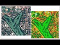 Object-based Image classification in QGIS || OBIA !! || A complete Tutorial