Import OpenStreetMap data into AutoCAD drawings - Spatial Manager Blog
Many AutoCAD users, such as architects, surveyors, engineers, etc., often need access to territorial information as a basis for their own projects or their work related in some way to the territory
OpenStreetMap community has this kind of spatial information, which is freely available, supported by thousands of users worldwide and continuously updated (see the previous post in this Blog)
Spatial Manager™ for AutoCAD includes, as other products in the Spatial Manager™ suite, its own data provider to access the information in OpenStreetMap and import it as graphical objects and alphanumeric data (EED)
In this example, by using the search and navigation tools in the main OpenStreetMap website, we locate the spatial information relating to a given city and the search process is focused on a specific area of the city. Then, from this website, the information is exported to an OSM file which will be used in Spatial Manager™ for AutoCAD to import OpenStreetMap data into an AutoCAD drawing
The information to be imported into AutoCAD from the OSM file is segmented. First, the buildings are imported and automatically separated into different AutoCAD layers, according to their build type. Then, the routes are imported into another Layer
Also, we configure the application to perform a Coordinate Transformation to project the objects over the import process (OpenStreetMap information is defined using the WGS 84 Latitude-Longitude system -- EPSG: 4326)
Please, watch the video
Видео Import OpenStreetMap data into AutoCAD drawings - Spatial Manager Blog канала Spatial Manager
Показать
Комментарии отсутствуют
Информация о видео
Другие видео канала
 Three Ways To Import OpenStreetMap Data In SketchUp
 Como transformar un mapa de Google a un croquis de Autocad o illustrator
 AutoCAD Map 3D for Engineers
 Prise en main des outils et données OpenStreetMap (Adrien PAVIE)
 OpenStreetMap 3D City Generator
 Tutorial Schwarzplan via Openstreetmap
 AutoCAD Map 3d - Import ShapeFile (.shp)
 Downloading from Digimap for AutoCAD 2019
 How to Convert KMZ Google Earth to DWG AutoCAD File | Convert KMZ to Excel with Points and Elevation
 All about using maps in AutoCAD
 Openstreetmaps to Illustrator
 How to convert open street map data to AutoCAD?
![Google Earth Master Plan in Photoshop [ Quickest Method ]](https://i.ytimg.com/vi/vYd9OhHCDuM/default.jpg) Google Earth Master Plan in Photoshop [ Quickest Method ]
Google Earth Master Plan in Photoshop [ Quickest Method ] Autocad 2018 - How to draw a Location Site Plan
 10.06.20 Вебинар "Интеграция возможностей ГИС в процессы проектирования с AutoCAD MAP 3D"
 BEST FREE websites for mapping | Free base map files for site analysis
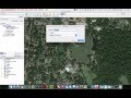 Inserting and Scaling Aerial Images in AutoCAD
 How to extract contour lines And DEM from Google Earth
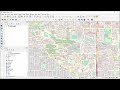 Extracting Data from OpenStreetMap using QGIS & QuickOSM
 Cara Memasukkan Gambar Peta Google Earth ke Autocad sesuai Skala