Autocad 2018 - How to draw a Location Site Plan
In this video I explain how to draw a location site plan by inserting an external image. I show you how to scale the image, trim in and drawing some details more.
Contents:
-Download image from Google Earth 0:16
-Import image to the drawing 1:21
-scale the drawing 2:25
-Draw the location plan 4:45
-Draw the legend 8:55
If you have any questions or comments please feel free to post :).
Licence:
The video shows the version 2018 of AutoCAD® and a version of Google Earth Pro. They are used exclusively for educational purposes.
Autodesk screen shots reprinted courtesy of Autodesk, Inc.
The narration and all the illustrations were created by CAD in Black.
Видео Autocad 2018 - How to draw a Location Site Plan канала CAD in black
Показать
Комментарии отсутствуют
Информация о видео
Другие видео канала
 INSERTING GOOGLE EARTH IMAGE TO AUTOCAD | MAKE SITE PLAN IN AUTOCAD USING GOOGLE EARTH
 How to: PLOT PROPERTY BEARINGS in AutoCAD 2020
 Autocad - Complete floor plan for beginners - Exercise: Care home
 Google Earth Master Plan in Photoshop
 3 FREE Digimap Alternatives for Site Analysis and Site Plans
 AutoCAD Print Setup ( sheets, scale, export to PDF ) Tutorial
 How to use proper scale in AutoCAD drawings - Part 1 of 2
 Import OpenStreetMap data into AutoCAD drawings - Spatial Manager Blog
 Creating and Preparing Autocad layers and layouts for Photoshop import
 MAKING CIVIL SITE PLAN USING AutoCAD | AutoCAD CIVIL PLAN
 How to import X Y coordinates from Excel to AutoCAD direct! (English)
![Google Earth Master Plan in Photoshop [ Quickest Method ]](https://i.ytimg.com/vi/vYd9OhHCDuM/default.jpg) Google Earth Master Plan in Photoshop [ Quickest Method ]
Google Earth Master Plan in Photoshop [ Quickest Method ] AutoCad Tutorial | Site Plans using Geolocation
 Tutorial 301 Vicinity Map Tracing
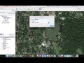 Inserting and Scaling Aerial Images in AutoCAD
 Webinar: Introduction to Layouts, Viewports, and Plotting in AutoCAD 2018 | AutoCAD LT
 | Site Plan | How to draw a Site Plan | Explained by Rohan Dasgupta |
 How to Convert KMZ Google Earth to DWG AutoCAD File | Convert KMZ to Excel with Points and Elevation
 All about using maps in AutoCAD