QGIS User 0018 - Georeferencer
A quick look at the QGIS Georeferencer that helps you place scanned maps or downloaded pictures, correctly on a map.
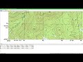
1. Try and select a map projection that is close to the scanned map original. Use that in your QGIS project and in the georeferencer.
2. Start with at least two points, so that you can select "linear" transformation and activate the link between the georeferencer and QGIS.
3. If you have high residual numbers for your additional points, you need to increase the transformation complexity. You need to balance this with sufficient number of reference points.
4. Try the georeferensing in QGIS, set some transparency to check it. Repeat and edit the points and transformation settings as needed.
Pro Tip:
If your scanned map is rotated, you can rotate the QGIS Canvas to match when you are using the georeferencer.
Видео QGIS User 0018 - Georeferencer канала Klas Karlsson
Показать
Комментарии отсутствуют
Информация о видео
Другие видео канала
 Georeferencing a scanned map and digitizing vectors in QGIS3
 How to Georeference a Map (PDF/JPEG) in QGIS
 Qgis User 0009 - Atlas
 QGIS User 0026 - Satellite Imagery to GPKG
 QGIS User 0024 - GeoPackage
 Georreferenciar una imagen con QGIS
 Georeferencing in QGIS 3 | burdGIS
 How to georeference an image with QGIS!
 QGIS & Ecology Georeferencing vector layers Affine transformations
 QGIS User 0033 - Creating Point Clouds
 Table Joining in QGIS || Join Attribute Table in QGIS || QGIS || IT GIS
 Resampling techniques
 Generate DEM from contours in QGIS
 QGIS Georeferencing Google Earth Images
 An Introduction to GRASS GIS
 QGIS User 0025 - Complex Labels
 Drillhole survey in QGIS
 Testing the experimental MSI installer and point cloud support in QGIS 3.18
 QGIS 3 for Absolute Beginners