QGIS Georeferencing Google Earth Images
In this tutorial we export a google image and kml file from Google Earth Pro. The kml layer is then used in QGIS as the control points in georeferencing the image in QGIS.
Видео QGIS Georeferencing Google Earth Images канала Q-tips
Видео QGIS Georeferencing Google Earth Images канала Q-tips
Показать
Комментарии отсутствуют
Информация о видео
Другие видео канала
 QGIS 3 for Absolute Beginners
 Download and georeference Google Earth images in QGIS 3.1 with Quickmap Service Plugin
 How to extract contour lines And DEM from Google Earth
 Google Earth Advanced Tools Tutorial
 Download and georeference Google Earth Images Using ARC GIS & Build Complete Database
 18 Places Google Earth Doesn't Want You to See
 How to Georeference a Map (PDF/JPEG) in QGIS
 Making a Map Using QGIS
 How to georeference an image with QGIS!
 Importing CSV (Excel) Coordinates into QGIS
 Image to image georeferencing in QGIS 3.4
 Google Earth Engine in QGIS - QGIS GEE 01 | burdGIS
 QGIS clipping and merging rasters
 QGIS and Google Earth
 Formation QGIS Georeferencement partie 1
 An Absolute Beginner's Guide to QGIS 3
 Download and georeference Google Earth images in QGIS 2.8 with OpenLayers Plugin
 Making GIS Map using Google Earth Pro and QGIS
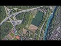 Trick to download Google earth image and georeference it
 Georeferencing a scanned map and digitizing vectors in QGIS3