Working with Terrain Data in Global Mapper
Following on from December’s webinar, during which we introduced the LiDAR processing functionality of Global Mapper, in January’s presentation, we explore the various analysis tools in the software that involve the use of terrain data. Global Mapper's 3D modeling and analysis functionality has been a major development focus over recent years and for many users, the utilization of the z-value is the most important facet of the application. Among the specific topics covered in the webinar are:
- Accessing terrain data
- Terrain creation
- Contour generation
- Line-of-sight analysis
- Viewshed analysis
- Volume calculation
- Terrain flattening
- Watershed modeling
- Slope analysis
Видео Working with Terrain Data in Global Mapper канала Blue Marble Geographics
- Accessing terrain data
- Terrain creation
- Contour generation
- Line-of-sight analysis
- Viewshed analysis
- Volume calculation
- Terrain flattening
- Watershed modeling
- Slope analysis
Видео Working with Terrain Data in Global Mapper канала Blue Marble Geographics
Показать
Комментарии отсутствуют
Информация о видео
Другие видео канала
 Top 10 Global Mapper Features
 Analyzing Terrain in Global Mapper
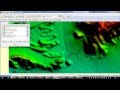 calculate the volume of reservoir of DAM
 Downloading Digital Elevation Data (SRTM) from USGS EarthExplorer
 Global Mapper Tutorials - Generating Contours
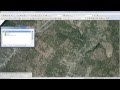 UAV Data Processing in Global Mapper
 Introduction to Global Mapper - lesson 1
 Ask the Experts: Creating a Continuous Digital Terrain Model
 Ask the Experts: What is the 3D buffer tool?
 Easiest way to calculate the volume of CUT and FILL using Global Mapper V21.0
 Global Mapper - Colorizing Point Clouds LiDAR using Orthophoto RGB
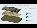 Terreno de google earth en archicad.
 Raster Processing in Global Mapper
 How to Clip Satellite Image in Global Mapper.
 how to creat contour from google earth using global mapper
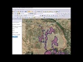 Flooding analysis, work flow with Global Mapper
 Working with Vector Data in Global Mapper
 Top New Features in Global Mapper Version 23.1
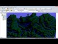 How to generate Watershed using Global Mapper 18
 Visualisasi Data 3D di Global Mapper