Global Mapper Tutorials - Generating Contours
In this short video tutorial, we explore Global Mapper's contour creation capability and we discuss the various option and settings that can applied during the process.
Use the links below to jump ahead to a specific section:
- Contour Generation Options (0 - 7:39)
- Smoothing Selected Contour Lines (7:40 - 9:28)
- Removing Polygons by Line Length (9:29 - 11:27)
- Contour Labels and Index Contours (11:28 - 14:06)
- Defining Zoom Level Ranges (14:07 - 19:05)
- Generating Elevation Polygons with the Create Contours Tool (19:06 - 22:15)
If you have questions about this topic or or about any other Global Mapper feature or function, email geohelp@bluemarblegeo.com
If you are new to Global Mapper, you can download a free trial version at globalmapper.com/download
Видео Global Mapper Tutorials - Generating Contours канала Blue Marble Geographics
Показать
Комментарии отсутствуют
Информация о видео
Другие видео канала
 Most easy way to EXTRACT CONTOURS from GOOGLE EARTH directly in AUTO CAD using GLOBAL MAPPER
 Analyzing Terrain in Global Mapper
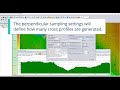 Tips & Tricks: How to Export 3D Path Profile Lines of a Stream in Global Mapper
 How to extract contour lines And DEM from Google Earth
 Point Cloud Segmentation Analysis in Global Mapper Pro
 Cropping a raster file in Global Mapper
 how to create contour by global mapper
 Global Mapper地形資料多種分析與展示工具
 Generating Contours from Point Clouds in GlobalMapper
 The ABC's of Global Mapper
 Global Mapper Tips and Tricks, Part 2
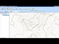 Generate contour lines from raster DEM terrain grid in Global Mapper
 Working with Terrain Data in Global Mapper
 Creating Maps for Outdoor Recreation in Global Mapper
 How to Create Contour Line Global Mapper
 Global Mapper - Colorizing Point Clouds LiDAR using Orthophoto RGB
 Tạo 3D fly through video bằng Global Mapper
 Top 10 Global Mapper Features
 Import contour from Global Mapper to Civil 3D
 how to creat contour from google earth using global mapper