Severe Cyclone Herman Satellite Imagery.
(Severe Cyclone Herman Satellite Imagery.)
Edited by; SuperTyphoon Tracker
Sources; Twitter/Googlewikipidia
Original Music; From Force Thirteen
1998 Pacific Typhoon Season Animation V3
https://youtu.be/9QbdwAhH84c
On 27 March, the JTWC began monitoring an area of convection. Satellite imagery showed that flaring convection which was circulating over the obscured LLCC. During 29 March, the BoM subsequently initiated advisories on the system and classified it as Tropical Low 21U. By 02:00 UTC that day, the JTWC issued a TCFA, and upgraded the system to a Tropical Cyclone 17S. Later that day, the BoM's reported that the tropical low had developed into a Category 1 tropical cyclone on the Australian scale and named it Herman. Later, the BoM's assessed the cyclone to have strengthened into a 95 km/h (60 mph). Herman intensified further with an eye feature starting to appear on microwave imagery.
Multispectral animated satellite imagery revealed an exposed LLCC with deep convection persisting along the western periphery of the LLCC and reaching 1-minute maximum sustained winds of 130 km/h (80 mph). Herman had further intensified to a Category 4-cyclone due to the presence of a well-defined eye. while the JTWC upgraded Herman to the equivalent of a Category 3-equivalent cyclone with winds of 205 km/h (125 mph). Continuing to rapidly intensify, Herman then strengthened into a Category 5 severe tropical cyclone. Herman was highly compact, with a distinct eye surrounded by cold cloud tops. The storm continued to weaken, the BoM's estimated winds of 195 km/h (120 mph). Herman became increasingly ragged and elongated as deep convection diminished and started to become displaced. During 2 April, while continuing to weaken, both the BoM and JTWC ceased issuing advisories.
#cycloneherman
#severecycloneherman
#20222023australianregioncycloneseason
#subscribe
Видео Severe Cyclone Herman Satellite Imagery. канала SuperTyphoon Tracker
Показать
Комментарии отсутствуют
Информация о видео
Другие видео канала
 Super Typhoon Yutu/RositaPH Satellite Imagery.
 Typhoon Lan Satellite Imagery.
 Major Hurricane Roslyn Track and Satellite Imagery.
 Typhoon Nalgae/PaengPH Satellite Imagery.
 Tropical Outlook for (April 10, 2022) Tropical Storm Malakas/TD(03W)AgatonPH(96W) Activity Update.
 Hurricane Danielle Satellite Imagery.
 Cyclone Gabrielle Satellite Imagery.
 Cyclone Tej Satellite Imagery.
 Hurricane Wilma Satellite Imagery.
 Super Typhoon Ivan(NarsingPH) and Joan Satellite Imagery.
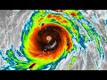 Super Typhoon Meranti/FerdiePH Satellite Imagery.
 2022 Pacific Typhoon Season (Naming List)
 Super Typhoon Bolaven Satellite Imagery.
 Tropical Outlook (January 21,2022) an LPA may have a chance to develop outside/inside the (PAR)
 Tropical Outlook (February 3, 2022) Surge of North East Moonson and Unorganized Weak Tropical Wave.
 Twin Supertyphoon Ivan and Joan on 1997PacificTyphoonSeason
 8 years ago On this day Supertyphoon Haiyan(Yolanda) devastated the Country of the Philippines
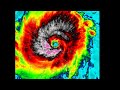 Major Typhoon Kammuri/TisoyPH Satellite Imagery.
 Here take a look👀 when gfs goes crazy🌀
 2021 Pacific Typhoon Season (Satellite Imagery) Edited by➡️(SupertyphoonTracker)