Major Typhoon Kammuri/TisoyPH Satellite Imagery.
(Major Typhoon Kammuri/TisoyPH Satellite Imagery.)
(Edited by: SuperTyphoon Tracker)
Sources: Twitter/Googlewikipidia
Original Music: From Force Thirteen
⬇️⬇️⬇️
1958 Pacific Typhoon Season Animation
https://www.youtube.com/watch?v=UMbDcVBez8k
Typhoon Kammuri, known in the Philippines as Typhoon Tisoy, was a powerful typhoon which impacted the Philippines in early December 2019. The twenty-eighth named storm and sixteenth typhoon of the 2019 Pacific typhoon season, Kammuri developed from a tropical wave situated a couple hundred kilometers south of the Mariana Islands. From November 25 to 27, the system tracked westward at a steady pace and rate of intensification, first making minor impacts in Guam. On November 28, the system intensified into a typhoon as environmental conditions became marginally conducive for significant development. From November 29 to December 1, Kammuri was unable to strengthen to previous estimates due to its near stationary movement as a result of weak steering currents, upwelling itself consequently. On December 2, the system tracked westward at a much faster speed of 19 km/h (12 mph) and rapidly intensified over warm Philippine Sea waters, before making landfall in the Bicol Region of the Philippines at peak intensity as a category 4-equivalent typhoon.
Upon leaving the Philippines, Kammuri significantly weakened as wind shear increased and interaction with the Philippine islands caused the structure of the system to degrade rapidly, and throughout December 3, it stayed as a category 1-equivalent typhoon, with its outer rainbands barely on land. By December 4, Kammuri drifted over the South China Sea as a weakening tropical storm. Through December 5 and 6, Kammuri weakened significantly and its low-level circulation center became exposed; as a result, it dissipated on December 6.
#typhoonkammuri
#typhoontisoyph
#2019pacifictyphoonseason
#westernpacific
#subscribe
Видео Major Typhoon Kammuri/TisoyPH Satellite Imagery. канала SuperTyphoon Tracker
Показать
Комментарии отсутствуют
Информация о видео
Другие видео канала
 Super Typhoon Yutu/RositaPH Satellite Imagery.
 Typhoon Lan Satellite Imagery.
 Major Hurricane Roslyn Track and Satellite Imagery.
 Typhoon Nalgae/PaengPH Satellite Imagery.
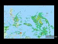 Tropical Outlook for (April 10, 2022) Tropical Storm Malakas/TD(03W)AgatonPH(96W) Activity Update.
 Hurricane Danielle Satellite Imagery.
 Cyclone Gabrielle Satellite Imagery.
 Severe Cyclone Herman Satellite Imagery.
 Cyclone Tej Satellite Imagery.
 Hurricane Wilma Satellite Imagery.
 Super Typhoon Ivan(NarsingPH) and Joan Satellite Imagery.
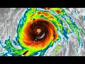 Super Typhoon Meranti/FerdiePH Satellite Imagery.
 2022 Pacific Typhoon Season (Naming List)
 Super Typhoon Bolaven Satellite Imagery.
 Tropical Outlook (January 21,2022) an LPA may have a chance to develop outside/inside the (PAR)
 Tropical Outlook (February 3, 2022) Surge of North East Moonson and Unorganized Weak Tropical Wave.
 Twin Supertyphoon Ivan and Joan on 1997PacificTyphoonSeason
 8 years ago On this day Supertyphoon Haiyan(Yolanda) devastated the Country of the Philippines
 Here take a look👀 when gfs goes crazy🌀
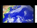 2021 Pacific Typhoon Season (Satellite Imagery) Edited by➡️(SupertyphoonTracker)