Hurricane Wilma Satellite Imagery.
(Hurricane Wilma Satellite Imagery.)
Edited by; SuperTyphoon Tracker
Sources; Twitter/Googlewikipidia
Original Music; From Force Thirtee
⬇️⬇️⬇️
Music#1 Elevation
Originally from Nathan Foy
Remade by Lucky Sevyn
https://youtu.be/UOeC7GAG6xc
Music#2
https://youtu.be/2vUVTxDZtzA
Hurricane Wilma was the most intense tropical cyclone ever recorded in the Atlantic basin, and the second-most intense tropical cyclone recorded in the Western Hemisphere, after Hurricane Patricia in 2015. Part of the record-breaking 2005 Atlantic hurricane season, which included three of the ten most intense Atlantic hurricanes in terms of barometric pressure (along with #4 Rita and #7 Katrina), Wilma was the twenty-second storm, thirteenth hurricane, sixth major hurricane, fourth Category 5 hurricane, and the second-most destructive hurricane of the 2005 season. Its origins came from a tropical depression that formed in the Caribbean Sea near Jamaica on October 15, headed westward, and intensified into a tropical storm two days later, which abruptly turned southward and was named Wilma. Wilma continued to strengthen, and eventually became a hurricane on October 18. Shortly thereafter, explosive intensification occurred, and in only 24 hours, Wilma became a Category 5 hurricane with wind speeds of 185 mph (298 km/h).
Wilma's intensity slowly leveled off after becoming a Category 5 hurricane, and winds had decreased to 150 mph (240 km/h) before it reached the Yucatán Peninsula on October 20 and 21. After crossing the Yucatán, Wilma emerged into the Gulf of Mexico as a Category 2 hurricane. As it began accelerating to the northeast, gradual re-intensification occurred, and the hurricane was upgraded to Category 3 status on October 24. Shortly thereafter, Wilma made landfall in Cape Romano, Florida, with winds of 120 mph (190 km/h). As Wilma was crossing Florida, it briefly weakened back to a Category 2 hurricane, but again re-intensified as it reached the Atlantic Ocean. The hurricane intensified into a Category 3 hurricane for the last time, before weakening while accelerating northeastward. By October 26, Wilma transitioned into an extratropical cyclone southeast of Nova Scotia.
Wilma made several landfalls, with the most destructive effects felt in the Yucatán Peninsula of Mexico, Cuba, and the U.S. state of Florida. At least 52 deaths were reported and damage totaled to $22.4 billion, most of which occurred in the United States. After Wilma, no major hurricane made landfall in the contiguous United States until Hurricane Harvey made landfall in southern Texas on August 26, 2017, ending a record period of 11 years and 10 months. During this time, major Atlantic hurricanes occurred slightly more frequently than average; they just either did not make landfall at that strength in the United States or just missed the United States entirely. Also, after Wilma, no hurricane struck the state of Florida until Hurricane Hermine did so nearly 11 years later in 2016, and no major hurricane struck Florida until nearly 12 years later when Hurricane Irma made landfall in early September 2017.
#hurricanewilma
#2005atlantichurricaneseason
#subscribe
Видео Hurricane Wilma Satellite Imagery. канала SuperTyphoon Tracker
Показать
Комментарии отсутствуют
Информация о видео
Другие видео канала
 Super Typhoon Yutu/RositaPH Satellite Imagery.
 Typhoon Lan Satellite Imagery.
 Major Hurricane Roslyn Track and Satellite Imagery.
 Typhoon Nalgae/PaengPH Satellite Imagery.
 Tropical Outlook for (April 10, 2022) Tropical Storm Malakas/TD(03W)AgatonPH(96W) Activity Update.
 Hurricane Danielle Satellite Imagery.
 Cyclone Gabrielle Satellite Imagery.
 Severe Cyclone Herman Satellite Imagery.
 Cyclone Tej Satellite Imagery.
 Super Typhoon Ivan(NarsingPH) and Joan Satellite Imagery.
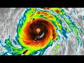 Super Typhoon Meranti/FerdiePH Satellite Imagery.
 2022 Pacific Typhoon Season (Naming List)
 Super Typhoon Bolaven Satellite Imagery.
 Tropical Outlook (January 21,2022) an LPA may have a chance to develop outside/inside the (PAR)
 Tropical Outlook (February 3, 2022) Surge of North East Moonson and Unorganized Weak Tropical Wave.
 Twin Supertyphoon Ivan and Joan on 1997PacificTyphoonSeason
 8 years ago On this day Supertyphoon Haiyan(Yolanda) devastated the Country of the Philippines
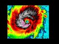 Major Typhoon Kammuri/TisoyPH Satellite Imagery.
 Here take a look👀 when gfs goes crazy🌀
 2021 Pacific Typhoon Season (Satellite Imagery) Edited by➡️(SupertyphoonTracker)