Automatic Extraction of Watershed using DEM data
This video shows how to extract automatically watershed or sub watershed using hydrology tool in ArcMap software.
Data Used: CartoDEM data
Software Used: ArcMap
Видео Automatic Extraction of Watershed using DEM data канала Michael Hembrom
Data Used: CartoDEM data
Software Used: ArcMap
Видео Automatic Extraction of Watershed using DEM data канала Michael Hembrom
Показать
Комментарии отсутствуют
Информация о видео
Другие видео канала
 Cara Membuat Peta DAS di ArcGIS 10.8 - Analisis 2
 Georeferencing Survey Of India Toposheet using ESRI's Arcgis Software
 How to extract Sub-Watershed with geometry from DEM in ArcGIS
 Stream and catchment delineation with GIS (theory)
 Climate Data (Temperature, Precipitation, Humidity) from 1981-2020
 Complete Hydrological Modeling in ArcMap/ ArcGIS
 Delineating Multiple Watersheds using Spatial Analyst Tool of ArcGIS
 Watershed Delineation using ArcSWAT Extension of ArcGIS from DEM data: very short and easy
 Arc Hydro Tools (Drainage Extraction) - ArcMap - Hydrologyl Study in ArcMap
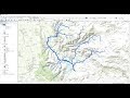 Stream Order from a Digital Elevation Model (DEM) using ArcGIS
 Detail Watershed Delineation using DEM in #ArcGIS
 Delineating Watershed and Basins Using ArcGIS
 How to use a DEM to delineate a Watershed/Basin in ArcGIS
 Watershed and stream network delineation on large scale basins with QGIS 3 - Tutorial
 STUDY AREA Mapping
 Study Area extraction from Google Earth and Export in ArcMap
 Arcgis : Merge the raster datasets /fusionner raster arcgis /Mosaic raster dataset ArcGIS
 Manual watershed delineation is a five-step process
 Hydrological modeling in ArcGIS / ArcMap
 Tutoriel 4: Délimitation Des Cours d'Eau Et Des Bassins Versants