- Популярные видео
- Авто
- Видео-блоги
- ДТП, аварии
- Для маленьких
- Еда, напитки
- Животные
- Закон и право
- Знаменитости
- Игры
- Искусство
- Комедии
- Красота, мода
- Кулинария, рецепты
- Люди
- Мото
- Музыка
- Мультфильмы
- Наука, технологии
- Новости
- Образование
- Политика
- Праздники
- Приколы
- Природа
- Происшествия
- Путешествия
- Развлечения
- Ржач
- Семья
- Сериалы
- Спорт
- Стиль жизни
- ТВ передачи
- Танцы
- Технологии
- Товары
- Ужасы
- Фильмы
- Шоу-бизнес
- Юмор
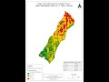
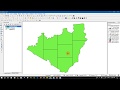
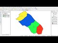
Slope Reclassification Process in QGIS #Step-3: Finalizing Reclassified Slope Map
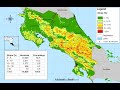
Slope maps are intended to fill in the gap regarding how steep an area is. Typically, we can measure this as either a degree value from one raster cell to the next of the Digital Elevation Models (DEMs) or DTM or as a percent/ratio.
Видео Slope Reclassification Process in QGIS #Step-3: Finalizing Reclassified Slope Map канала Kapil Dev Adhikari
Видео Slope Reclassification Process in QGIS #Step-3: Finalizing Reclassified Slope Map канала Kapil Dev Adhikari
Комментарии отсутствуют
Информация о видео
23 марта 2024 г. 22:46:35
00:15:16
Другие видео канала