- Популярные видео
- Авто
- Видео-блоги
- ДТП, аварии
- Для маленьких
- Еда, напитки
- Животные
- Закон и право
- Знаменитости
- Игры
- Искусство
- Комедии
- Красота, мода
- Кулинария, рецепты
- Люди
- Мото
- Музыка
- Мультфильмы
- Наука, технологии
- Новости
- Образование
- Политика
- Праздники
- Приколы
- Природа
- Происшествия
- Путешествия
- Развлечения
- Ржач
- Семья
- Сериалы
- Спорт
- Стиль жизни
- ТВ передачи
- Танцы
- Технологии
- Товары
- Ужасы
- Фильмы
- Шоу-бизнес
- Юмор
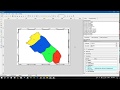
Block Division (split polygon) in Qgis
GPS XY data import and Polygons' Block Division in Qgis (Simple ways)
1. Goto Plugin toolbar,
1.1. Manage and install Plugins (In this tab you can change the settings for the plugin manager.) and Check the 'Show experimental plugins' checkbox and Reload repository tab.
# Plugins list to be installed.
a. Spreadsheet Layers
b. Points2One
c. Calculate Geometry
d. Digitizing Tools
e. GEarthView
f. QuickMapServices
g. XyTools
Now close the plugin manager
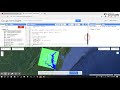
2. click on Add Spreadsheet Layers, import XY GPS data from the computer folder.
a. Select an excel sheet that contains XY/lat long data
b. Check on Geometry Checkbox
c. Select Reference System (CRS) from the Select tab
d. Point layer should be on the canvas.
3. Click on Points2One plugin (p2)
a. Input Vector layer: Point layer
b. Click on Create polygons
c. Click on Sort vertices by (S.N./ or Serial number id)
d. Save at computer folder and click on Add result to the canvas and ok.
e. Polygon layer should be on canvas.
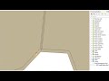
4. Area calculation method:
a. Open the attribute table of polygon
b. click on toggle the editing (yellow pencil) (CTRL+E)
c. click on New Field (CTRL+W) (Add required fields)
d. watch the video carefully and so on...
For more Qgis and GEE, tutorials watch and subscribe to my channel #https://www.youtube.com/channel/UCWYd4sdfstEDLWbJl7NvonA/playlists?view_as=subscriber
# Background music: @Alan Walker vs Coldplay - Hymn for the Weekend [https://youtu.be/8ebRM6vSYXw]
Видео Block Division (split polygon) in Qgis канала Kapil Dev Adhikari
1. Goto Plugin toolbar,
1.1. Manage and install Plugins (In this tab you can change the settings for the plugin manager.) and Check the 'Show experimental plugins' checkbox and Reload repository tab.
# Plugins list to be installed.
a. Spreadsheet Layers
b. Points2One
c. Calculate Geometry
d. Digitizing Tools
e. GEarthView
f. QuickMapServices
g. XyTools
Now close the plugin manager
2. click on Add Spreadsheet Layers, import XY GPS data from the computer folder.
a. Select an excel sheet that contains XY/lat long data
b. Check on Geometry Checkbox
c. Select Reference System (CRS) from the Select tab
d. Point layer should be on the canvas.
3. Click on Points2One plugin (p2)
a. Input Vector layer: Point layer
b. Click on Create polygons
c. Click on Sort vertices by (S.N./ or Serial number id)
d. Save at computer folder and click on Add result to the canvas and ok.
e. Polygon layer should be on canvas.
4. Area calculation method:
a. Open the attribute table of polygon
b. click on toggle the editing (yellow pencil) (CTRL+E)
c. click on New Field (CTRL+W) (Add required fields)
d. watch the video carefully and so on...
For more Qgis and GEE, tutorials watch and subscribe to my channel #https://www.youtube.com/channel/UCWYd4sdfstEDLWbJl7NvonA/playlists?view_as=subscriber
# Background music: @Alan Walker vs Coldplay - Hymn for the Weekend [https://youtu.be/8ebRM6vSYXw]
Видео Block Division (split polygon) in Qgis канала Kapil Dev Adhikari
Комментарии отсутствуют
Информация о видео
29 января 2019 г. 19:34:34
00:18:44
Другие видео канала