- Популярные видео
- Авто
- Видео-блоги
- ДТП, аварии
- Для маленьких
- Еда, напитки
- Животные
- Закон и право
- Знаменитости
- Игры
- Искусство
- Комедии
- Красота, мода
- Кулинария, рецепты
- Люди
- Мото
- Музыка
- Мультфильмы
- Наука, технологии
- Новости
- Образование
- Политика
- Праздники
- Приколы
- Природа
- Происшествия
- Путешествия
- Развлечения
- Ржач
- Семья
- Сериалы
- Спорт
- Стиль жизни
- ТВ передачи
- Танцы
- Технологии
- Товары
- Ужасы
- Фильмы
- Шоу-бизнес
- Юмор
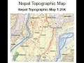
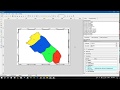
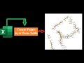
Reclassify Slope in Google Earth Engine using DEM
Create a slope raster using 30 m SRTM DEM and then reclassify it based on range of values (degree) in order to estimate what type of slope has the biggest coverage (area).
A Digital Elevation Model (DEM) file stores elevation data that can be used to extract slope parameters and to perform surface analysis.
GEE script link: https://drive.google.com/file/d/19ZlaxLuYiBueepczPMYNaWMc_GkDcIqC/view?usp=sharing
Видео Reclassify Slope in Google Earth Engine using DEM канала Kapil Adhikari
Комментарии отсутствуют
Информация о видео
2 июля 2021 г. 17:34:48
00:21:52
Другие видео канала