Create a Map with QGIS and Google Earth PRO (Water Supply Project Layout) - [Part 2]
PART ONE OF THIS QGIS TUTORIAL: https://youtu.be/HALa2-FJ2Ks
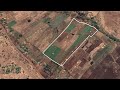
In today’s QGIS Tutorial, I am going to show you how to perform mapping and to produce a map or water supply project layout by using QGIS Software! We will use QGIS and Google Earth PRO because they are free and easy to use!
You will learn how to use different QGIS and Google Earth PRO tools for example how to prepare shapefiles, how to work with points in Google earth pro and so forth!
I believe this is going to be an informative video!
Eng. Lodrick
Hydroinformatics Academy
Видео Create a Map with QGIS and Google Earth PRO (Water Supply Project Layout) - [Part 2] канала Hydroinformatics Academy
Показать
Комментарии отсутствуют
Информация о видео
29 октября 2021 г. 20:13:54
00:40:42
Другие видео канала
 How I used CROPWAT 8.0 to Estimate the Amount of Water to Irrigate this Farm (has multiple Crops)
![How to Calculate Crop and Irrigation Water Requirement Using CROPWAT 8.0 and CLIMWAT 2.0 [Part - 3]](https://i.ytimg.com/vi/ZDRI4ZJVsrI/default.jpg) How to Calculate Crop and Irrigation Water Requirement Using CROPWAT 8.0 and CLIMWAT 2.0 [Part - 3]
How to Calculate Crop and Irrigation Water Requirement Using CROPWAT 8.0 and CLIMWAT 2.0 [Part - 3]![Pump Sizing with WaterGEMS Connect Edition [Rainwater Harvesting Network]](https://i.ytimg.com/vi/gevVCfKOc4U/default.jpg) Pump Sizing with WaterGEMS Connect Edition [Rainwater Harvesting Network]
Pump Sizing with WaterGEMS Connect Edition [Rainwater Harvesting Network] Extract Elevation Data FROM GOOGLE EARTH PRO | Google earth elevation data WITHOUT TCX Converter!
 Design Water Reticulation System with WaterGEMS Connect Edition
 Announcement: EPANET One-to-one Online Training for Water Engineers
![Hydraulic Modeling for Looped Water Supply Network with EPANET Software [Part - 02]](https://i.ytimg.com/vi/Q64ZenXOhkg/default.jpg) Hydraulic Modeling for Looped Water Supply Network with EPANET Software [Part - 02]
Hydraulic Modeling for Looped Water Supply Network with EPANET Software [Part - 02] Lets Design this Pumping Water network with WaterGEMS Software
![Strategies to Learn any Engineering Software [AutoCAD/EPANET/WaterGEMS]](https://i.ytimg.com/vi/3TCsEwf_Qyg/default.jpg) Strategies to Learn any Engineering Software [AutoCAD/EPANET/WaterGEMS]
Strategies to Learn any Engineering Software [AutoCAD/EPANET/WaterGEMS] Why Operation and Maintenance Cost is important in Engineering?
![How to Calculate Crop and Irrigation Water Requirement Using CROPWAT 8.0 and CLIMWAT 2.0 [Part - 5]](https://i.ytimg.com/vi/fMkC2CRTgrw/default.jpg) How to Calculate Crop and Irrigation Water Requirement Using CROPWAT 8.0 and CLIMWAT 2.0 [Part - 5]
How to Calculate Crop and Irrigation Water Requirement Using CROPWAT 8.0 and CLIMWAT 2.0 [Part - 5] Sizing Water Pump Without Pump Curve in WaterGEMS
 Why Water Distribution System Layout is Important Tool in your Work as an Engineer
 Convert Excel Data to Shapefile with QGIS Software
 How I Prepared this Water Network Layout in AutoCAD (After designing in WaterGEMS)
 Convert Excel Data to Geopackage with QGIS Software
![Hydraulic Modeling for Looped Water Supply Network with EPANET Software [Part - 01]](https://i.ytimg.com/vi/j4p3og_w6XA/default.jpg) Hydraulic Modeling for Looped Water Supply Network with EPANET Software [Part - 01]
Hydraulic Modeling for Looped Water Supply Network with EPANET Software [Part - 01]![WaterGEMS Connect Edition Tutorial for Beginners [Part - 02]](https://i.ytimg.com/vi/qfORV0GQm5o/default.jpg) WaterGEMS Connect Edition Tutorial for Beginners [Part - 02]
WaterGEMS Connect Edition Tutorial for Beginners [Part - 02]![EPANET Hydraulic Modeling For Groundwater Submersible Pump | EPANET Tutorial [Using Simple Trick]](https://i.ytimg.com/vi/2YDpuUtuNdY/default.jpg) EPANET Hydraulic Modeling For Groundwater Submersible Pump | EPANET Tutorial [Using Simple Trick]
EPANET Hydraulic Modeling For Groundwater Submersible Pump | EPANET Tutorial [Using Simple Trick] Important EPANET Settings - Part 1