Convert Excel Data to Geopackage with QGIS Software
Let's say as an engineer after a field survey you have your data in Excel but you want to convert your data to geopackage format! Well, it might be a little challenging but that is exactly what we are going to learn in this tutorial! And we'll see how to achieve that with the help of QGIS Software.
Not only that, but we will also learn how to import CSV data into QGIS and how to work with attribute tables!
Watch until the end and don't forget to like and share with your friends if you find this video informative!
Regards
Eng. Lodrick Thomas
@hydroinformatics Academy
=====
TIMESTAMPS
=====
00:00 Introduction (IMPORTANT!)
00:53 Import CSV data into QGIS
02:28 Export imported CSV data into Geopackage
==============
FOLLOW HYDROINFORMATICS ACADEMY ON SOCIAL MEDIA
==============
Telegram Channel: https://t.me/hydroinformaticsacademy
Linkedin Page: https://www.linkedin.com/company/hydroinformaticsacademy
Facebook Page: https://web.facebook.com/hydroinformaticsacademy
Want to support my channel? Here's Patreon Link: https://www.patreon.com/hydroinformaticsacademy
DISCLAIMER
=======
This is not engineering advice. Everything here is for informational and educational purposes only!
Видео Convert Excel Data to Geopackage with QGIS Software канала Hydroinformatics Academy
Показать
Комментарии отсутствуют
Информация о видео
19 сентября 2022 г. 14:00:07
00:04:44
Другие видео канала
 Why Head loss is Important Tool in Water Distribution System Design
 Use this Trick to get Exact Pipe Internal Diameter Value
 Why Water Distribution System Layout is Important Tool in your Work as an Engineer
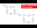 How I Prepared this Water Network Layout in AutoCAD (After designing in WaterGEMS)
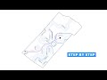 How I prepared a Contour Map for this Farm in QGIS Software
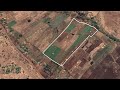 How I used CROPWAT 8.0 to Estimate the Amount of Water to Irrigate this Farm (has multiple Crops)
 This is How I Sized this Water Pump in EPANET Software
 How I Prepared this Water Network Layout in QGIS
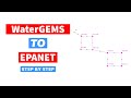 Exporting WaterGEMS files and Import in EPANET Software
![Pump Sizing with WaterGEMS Connect Edition [Rainwater Harvesting Network]](https://i.ytimg.com/vi/gevVCfKOc4U/default.jpg) Pump Sizing with WaterGEMS Connect Edition [Rainwater Harvesting Network]
Pump Sizing with WaterGEMS Connect Edition [Rainwater Harvesting Network] Sizing Water Pump Without Pump Curve in EPANET Software
 Sizing Water Pump Without Pump Curve in WaterGEMS
![Strategies to Learn any Engineering Software [AutoCAD/EPANET/WaterGEMS]](https://i.ytimg.com/vi/3TCsEwf_Qyg/default.jpg) Strategies to Learn any Engineering Software [AutoCAD/EPANET/WaterGEMS]
Strategies to Learn any Engineering Software [AutoCAD/EPANET/WaterGEMS] Sizing a Water Pump in WaterGEMS Software | WaterGEMS Tutorial
 Pump Sizing & Pumping Water Network Design with WaterGEMS Software | WaterGEMS Tutorial
 Convert Excel Data to Shapefile with QGIS Software
 Demand Center feature in WaterGEMS Connect Edition
 Extract Decimal Degrees/Latitudes Longitudes Coordinates in QGIS and Export to Excel
 Google Earth PRO as a Mapping Tool | Map making with Google Earth PRO
 Design Water Reticulation System with WaterGEMS Connect Edition