San Antonio River Begininng / The Blue Hole
Years ago I was blessed with the opportunity of researching San Antonio and her history. The following pictures I took after finding the city's source of life, the San Antonio River: the river I was born not to far from. The spring season was an especially wet one and springs were bubbling up all over campus. I thank God for this experience of seeing how He gives life to his creatures and sustains that life with his refreshing water.
http://www.uiw.edu/sanantonio/Headwaters.html
San Antonio River Headwaters Blue Hole
San Antonio is known for its river and primarily for the San Antonio Riverwalk. The history and origin of the San Antonio River begins on the campus of the University of the Incarnate Word. Although the San Antonio River has hundreds of springs and creeks feeding it on its journey to the Gulf of Mexico, the recognized source is what is known as the San Antonio Springs Blue Hole.
The Blue Hole - San Antonio Springs
Looking at the size and strength of the San Antonio River, one would hardly believe that the recognized headwaters consists of a rock encircled spring no larger than a backyard spa. In reality, the San Antonio River headwaters is made up of numerous springs as well as the combined flow of Olmos Creek. These springs, appropriately named the San Antonio Springs are all in the vicinity of the Blue Hole, with the Blue Hole being the largest and are fed by the Edwards Aquifer. When the aquifer level drops below 676 feet, the springs stop flowing and the Blue Hole is dry. The water running from the San Antonio Springs and Blue Hole is clear and beautiful. As the name implies, the Blue Hole has a blue tint to the water as it bubbles up out of the ground and makes its way downstream. This historical water landmark is protected by State and Federal law and is an excellent place for an afternoon stroll in a peaceful setting. The plaque on the edge of the Blue Hole reads:
"The historic source spring of the San Antonio River, San Antonio Spring has for centuries provided millions of gallons of crystal clear spring water daily to generations of Native Americans and early Texas Settlers. The San Antonio River begins just south of this point, near the campus footbridge, where the Olmos Creek and the San Antonio Spring flow come together and, supplemented by hundreds of smaller springs along the way, begins the journey to the Gulf of Mexico.
At one time the daily flow from the San Antonio spring was aid to be so strong at times that it produced a geyser many feet into the air. In the 19th century banker, philanthropist George Washington Brackenridge purchased this property and established the first San Antonio Water Works. The concrete rim around this spring, which goes deep underground to the southern boundary of the Edwards Aquifer in the Olmos Basin, was added by Brackenridge to control the water flow. In time, however, the addition of wells and pumps south of the Brackenridge property made the Water Works less than lucrative. These wells and pumps also reduced the natural spring flow.
The University added the current walkway to the Spring,and the natural limestone ledge in 1989. This made the spring more available to the campus and general community without the danger of accidentally falling into it. The stones used, with the natural indentations in the limestone, are excellent examples of the limestone formation which is the Edwards Aquifer, San Antonio's sole source of pure drinking water. In recent years San Antonio Spring is frequently dry, except after heavy rains. Natural flow begins when the aquifer water table is around 676 feet above sea level.
This source of pure water attracted settlers from prehistoric and historic times, and these people have left rich archaeological resources for future study. The San Antonio Spring, Brackenridge Villa, and the five distinct Texas Archaeological Landmarks west of the spot are on the National Register of Historic Places as the Source of the River Archaeological District. These sites are protected by State and Federal law, with hefty fines and penalties for tampering with protected sites and/or removing pre-historic or historic artifacts. Look, please, and enjoy it as generations have done before you, but leave it as you found it for generations yet to come."
Start of the San Antonio River
The actual San Antonio River begins underneath the footbridge on the University of the Incarnate Word campus. The physical location, underneath the bridge joins Olmos Creek with the creeks and streams of the San Antonio Springs (the Blue Hole and surrounding springs). The point at which the two primary streams converge, the water becomes extremely muddy and maintains its muddy color the length of the river. The point at which the two bodies of flowing river join is the very beginning of the San Antonio River.
http://www.informationsanantonio.com/toseeanddo/historicsanantonio/sanantonioriverbluehole.html
Видео San Antonio River Begininng / The Blue Hole канала remembranceTX
Показать
Комментарии отсутствуют
Информация о видео
Другие видео канала
 Jesus the High Priest and Lamb of God
 Worshipping God, Adoring God, Loving God
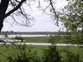 John Bernard's Spanish Land Grant
 Schwab
 My Family's Inheritance
 Mary, The Second Eve
 Magical Time of the Day
 Paschal Mystery: Lamb of God and the Prophet
 Jesus is the God of Abraham, Isaac, Jacob (Israel) and Moses
 Tamid, the Daily Offering
 Schwabs Migrate from Europe to Texas
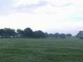 Frelsburg Texas
 The Treasures of Las Vegas
 Holy Ground , The Real Presence of Jesus