Google Earth Image Overlay in AutoCAD
In this Video, I will demonstrate how to add a google earth image into AutoCAD using your project coordinate system.
There was an option to import google earth image to Civil3D, however, those options were only available up to 2012 version of Civil 3D.
Civil3d has the geolocation tab to insert aerial maps, this command uses map imagery from Bing maps.
Bing maps are sometimes not updated like google earth, which we often need for Civil 3D or Map.
The method I’m sharing here is very simple and you just need normal AutoCAD and Google earth or
Google Earth Pro (which will provide a better quality image).
Automatic Sheet Layout creating Lisp program: https://youtu.be/SY6Y2g5YwE0
Click the Below link for more useful Tips and Tricks.
https://goo.gl/DCR3Ld
Please LIKE this video and Subscribe my Chanel.
Thank you, Blaine, for motivating me to create this channel and for all the support.
Check out awesome Cooking videos from Blaine's wife
https://www.youtube.com/channel/UCFV2I3T_AVPBVIK23rOQB4Q
Please Watch below Interesting Civil Engineering Project work in progress videos.
https://goo.gl/zcFyKt
https://goo.gl/yMKa1b
For CIVIL3D Roadway Modeling Online Training, contact www.BIM-Infra.net
Видео Google Earth Image Overlay in AutoCAD канала CAD MAN
Показать
Комментарии отсутствуют
Информация о видео
Другие видео канала
 Create contour lines from Google Earth on AutoCAD - (Free - Open Source)
 AutoCAD Tutorial; Insert, georeference google earth image
 AutoCAD to KML / AutoCAD to Google Earth
 Import OpenStreetMap data into AutoCAD drawings - Spatial Manager Blog
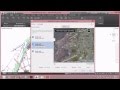 How to Set Geo Location in AutoCad?
 INSERTING GOOGLE EARTH IMAGE TO AUTOCAD | MAKE SITE PLAN IN AUTOCAD USING GOOGLE EARTH
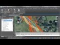 Civil 3D Bing Maps & Google Earth Integration
 Extract Coordinates (Lat/Long) from Google Earth Pro | then export to UTM
 Adding a Google Earth Image to AutoCAD (and Georeferencing)
 Most easy way to EXTRACT CONTOURS from GOOGLE EARTH directly in AUTO CAD using GLOBAL MAPPER
 How to import X Y coordinates from Excel to AutoCAD direct! (English)
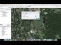 Inserting and Scaling Aerial Images in AutoCAD
 Import Google Earth Image to Auto CAD & Impose Auto CAD Coordinated Plan
 How to Convert GOOGLE EARTH CONTOURS to AUTOCAD by TCX converter + QUICK GRID or SURFER (DEM)
 JOINING OF REVENUE VILLAGE MAPS IN AUTOCAD
 AutoCAD Civil 3D Coordinate Conversion
 Video Tutorial 010 Autocad Scale Google Earth for Site Plan
 Inserting Google Earth Image to AutoCAD | Google Earth to AutoCAD
 How to extract contour lines And DEM from Google Earth
 GeoLocation in AutoCAD | Google Map overlay in AutoCAD | Online Satellite Map in AutoCAD