How to Change Point Styles in AutoCAD | How to Perform Point Style Settings in AutoCAD
Setting the size in absolute units means that the size of an object is specified in a fixed, physical measurement, such as millimeters, inches, or centimeters. This allows you to control the exact size of an object, regardless of the display resolution or size of the screen it is being displayed on. For example, if you set the point size to 5mm in AutoCAD, the point will always appear with a diameter of 5mm, no matter the display resolution of the screen it is being viewed on. This can be useful for precise, technical drawings where accurate dimensions are important.
Setting the size relative to screen means that the size of an element is determined based on the size of the screen or display it is being viewed on. This means that the size of the element will adjust dynamically based on the size of the screen, so it will appear larger or smaller depending on the display size. This helps to ensure that the element fits comfortably on any screen and can be seen clearly without having to scroll or zoom in.
Видео How to Change Point Styles in AutoCAD | How to Perform Point Style Settings in AutoCAD канала Surveying Solutions
Показать
Комментарии отсутствуют
Информация о видео
Другие видео канала
 Buffering with Python Command on ArcGIS Pro
 Insert Google Earth Image into AutoCAD | Align (Georeference) the Image on AutoCAD
 How to Produce Index Maps using ArcGIS
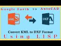 How to Convert KML File to AutoCAD Drawing using LISP | AutoCAD LISP
 Calculator Tricks | Casio Fx 991ES Plus | Secrets to Get the Best of YOUR Calculator.
 How to Scale in AutoCAD | Scale to Specific Length | Scale Factor
 How to do Buffer Analysis in GIS | Buffer in GIS
 Gridding Methods in Surfer | How to Grid X, Y, Z Data on Surfer.
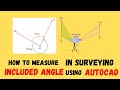 Included Angle in Surveying | Angle at a Point
 Live Location Share WhatsApp | Live Location on WhatsApp
 SURCON Photogrammetry Lecture Notes with Solutions 2022. 📡
 How to Convert DMS to DD using Surfer
 How to Convert Shapefiles to DXF using Global Mapper | SHP to DXF
 How To Calculate Area On Mobile Google Earth 2022 | LAND SURVEY App.
 Included Angle in Traversing (Manual Computation) | Included Angle in Surveying
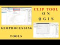 Clip Vector Layer using QGIS | Geoprocessing Tool | Clip Tool
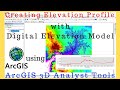 Creating Elevation Profile from DEM with 3D Analyst Tool using ArcGIS | Create Profiles using DEM
 How to Find UTM Zone of any Location |Google Earth |Understanding Coordinate Reference System in GIS
 Flight Planning in Photogrammetry | Aerial Mapping/Survey | Calculations of Flight Planning Data
 QGIS Research Tools | Generate Regular Points in QGIS and Determine their Coordinates