Two LPAs (Invests 94W and 95W), Shear Line and ITCZ | Weather Vlog 109 | April 3, 2022
Two LPAs (Invests 94W and 95W), Shear Line and ITCZ | Weather Vlog 109 | April 3, 2022
Link: https://youtu.be/9CHS3FCjT7s
My YouTube Channel: Tropical Storm Watcher
Link: https://www.youtube.com/channel/UCd1ooXFOu0x_i_MpZALEZJw
Note/Disclaimer:
1.) I gathered all information from different weather agencies and forecast models.
2.) I labelled the satellite photo to indicate the weather systems.
3.) The forecasts will change.
4.) This is not an official update. I summarize the weather updates and tropical cyclone formation forecasts. Please confirm on official weather websites and social media.
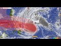
The time and date of this satellite photo is as of 7:45 AM of April 1, 2022 (Friday) (Philippine Standard Time).
A low pressure area (LPA, Invest 94W) was located at 88 km. east-southeast (ESE) of Yap Island, Fed. States of Micronesia (9.3°N, 138.9°E; As of 2 AM, April 3, 2022, Sunday, PhT). Based on the forecast models as of this moment, it has 10% - 50% (very low to medium/moderate) chance to become a tropical cyclone within the next 2-5 days. It will enter the Philippine Area of Responsibility (PAR) within the next 18-24 hours.
Meanwhile, another low pressure area (LPA, Invest 95W) was located at 286 km. southeast (SE) of Pohnpei State, Fed. States of Micronesia (4.6°N, 159.5°E; As of 2 AM, April 3, 2022, Sunday, PhT). Based on the forecast models as of this moment, it has 25% - 70% (low to moderately high) chance to become a tropical cyclone within the next 2-5 days. It will enter the Philippine Area of Responsibility (PAR) within the next 5-9 days.
Meanwhile, the shear line currently affects Cagayan Valley, Apayao, and Ilocos Norte, which brings cloudy skies with scattered rainshowers and thunderstorms with possible flash floods or landslides during during moderate to at times heavy rains.
Meanwhile, the Intertropical Convergence Zone (ITCZ) currently affects Visayas, Mindanao, Masbate, and Sorsogon, which brings cloudy skies with scattered rainshowers and thunderstorms with possible flash floods or landslides during during moderate to at times heavy rains.
Meanwhile, Metro Manila and the rest of Luzon is currently experiencing partly cloudy to cloudy skies with isolated rainshowers or thunderstorms with possible flash floods or landslides during severe thunderstorms caused by localized thunderstorms and easterlies.
La Niña Update 2021-2022 (by PAGASA):
La Niña is weakening and is likely to continue into the April-May-June 2022 season and then return to ENSO-neutral levels in May-Jun-Jul 2022. La Nina increases the likelihood of having above normal rainfall conditions in some areas of the country.
Please refer to PAGASA website and Facebook page, as well as other weather agencies for more information, rainfall warning updates, tropical cyclone wind signals, and other specific updates.
STAY TUNED FOR MORE UPDATES!!! 👍🏼👍🏼👍🏼
Sources:
1.) Windy.com (www.windy.com)
2.) PAGASA (http://bagong.pagasa.dost.gov.ph/)
3.) Easterlywave.com (https://www.easterlywave.com/typhoon/ensemble/)
4.) Tropical Tidbits (https://www.tropicaltidbits.com/storminfo)
Music: Escape from the Temple - Per Kiilstofte
Thank you for watching!!! 😀😊
#Invest94W #Invest95W #Philippines
Видео Two LPAs (Invests 94W and 95W), Shear Line and ITCZ | Weather Vlog 109 | April 3, 2022 канала Tropical Storm Watcher
Link: https://youtu.be/9CHS3FCjT7s
My YouTube Channel: Tropical Storm Watcher
Link: https://www.youtube.com/channel/UCd1ooXFOu0x_i_MpZALEZJw
Note/Disclaimer:
1.) I gathered all information from different weather agencies and forecast models.
2.) I labelled the satellite photo to indicate the weather systems.
3.) The forecasts will change.
4.) This is not an official update. I summarize the weather updates and tropical cyclone formation forecasts. Please confirm on official weather websites and social media.
The time and date of this satellite photo is as of 7:45 AM of April 1, 2022 (Friday) (Philippine Standard Time).
A low pressure area (LPA, Invest 94W) was located at 88 km. east-southeast (ESE) of Yap Island, Fed. States of Micronesia (9.3°N, 138.9°E; As of 2 AM, April 3, 2022, Sunday, PhT). Based on the forecast models as of this moment, it has 10% - 50% (very low to medium/moderate) chance to become a tropical cyclone within the next 2-5 days. It will enter the Philippine Area of Responsibility (PAR) within the next 18-24 hours.
Meanwhile, another low pressure area (LPA, Invest 95W) was located at 286 km. southeast (SE) of Pohnpei State, Fed. States of Micronesia (4.6°N, 159.5°E; As of 2 AM, April 3, 2022, Sunday, PhT). Based on the forecast models as of this moment, it has 25% - 70% (low to moderately high) chance to become a tropical cyclone within the next 2-5 days. It will enter the Philippine Area of Responsibility (PAR) within the next 5-9 days.
Meanwhile, the shear line currently affects Cagayan Valley, Apayao, and Ilocos Norte, which brings cloudy skies with scattered rainshowers and thunderstorms with possible flash floods or landslides during during moderate to at times heavy rains.
Meanwhile, the Intertropical Convergence Zone (ITCZ) currently affects Visayas, Mindanao, Masbate, and Sorsogon, which brings cloudy skies with scattered rainshowers and thunderstorms with possible flash floods or landslides during during moderate to at times heavy rains.
Meanwhile, Metro Manila and the rest of Luzon is currently experiencing partly cloudy to cloudy skies with isolated rainshowers or thunderstorms with possible flash floods or landslides during severe thunderstorms caused by localized thunderstorms and easterlies.
La Niña Update 2021-2022 (by PAGASA):
La Niña is weakening and is likely to continue into the April-May-June 2022 season and then return to ENSO-neutral levels in May-Jun-Jul 2022. La Nina increases the likelihood of having above normal rainfall conditions in some areas of the country.
Please refer to PAGASA website and Facebook page, as well as other weather agencies for more information, rainfall warning updates, tropical cyclone wind signals, and other specific updates.
STAY TUNED FOR MORE UPDATES!!! 👍🏼👍🏼👍🏼
Sources:
1.) Windy.com (www.windy.com)
2.) PAGASA (http://bagong.pagasa.dost.gov.ph/)
3.) Easterlywave.com (https://www.easterlywave.com/typhoon/ensemble/)
4.) Tropical Tidbits (https://www.tropicaltidbits.com/storminfo)
Music: Escape from the Temple - Per Kiilstofte
Thank you for watching!!! 😀😊
#Invest94W #Invest95W #Philippines
Видео Two LPAs (Invests 94W and 95W), Shear Line and ITCZ | Weather Vlog 109 | April 3, 2022 канала Tropical Storm Watcher
Показать
Комментарии отсутствуют
Информация о видео
Другие видео канала
 Typhoon Odette (Rai) | Weather Vlog 95 | December 15, 2021
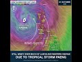 Tropical Storm Paeng's Wind Gust over Luzon and Western Visayas
 Philippine Weather Outlook for December 2-3, 2020
 Historical Facts of Typhoon Ondoy (Ketsana) of 2009
 Philippine Weather Outlook 19 | Weather Vlog 19 | January 11, 2021
 Low Pressure Area (Invest 91W) and Amihan | Weather Vlog 105 | January 25, 2022
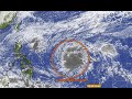 Tropical Storm Nyatoh (27W) | Weather Vlog 83 | November 30, 2021
 Announcement (June 5, 2022)
 Tropical Storm Dante (Choi-wan) | Weather Vlog 38 | May 31, 2021
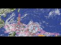 ITCZ and 2 LPAs | Weather Vlog 50 | Sept. 17-18, 2021