Converting a table of Lat / Long values into a Shapefile
Jeff Blossom: step-by-step instructions for bringing tabular data (in an Excel spreadsheet) into ArcMap 10, and creating a points layer from x, y coordinates entered in the spreadsheet. The layer is then saved to a Shapefile for use in GIS.
CGA Training Module 1 - Feb 2011
Видео Converting a table of Lat / Long values into a Shapefile канала Harvard CGA
CGA Training Module 1 - Feb 2011
Видео Converting a table of Lat / Long values into a Shapefile канала Harvard CGA
Показать
Комментарии отсутствуют
Информация о видео
Другие видео канала
 ArcGIS Coordinate Transformation
 An Absolute Beginner's Guide to QGIS 3
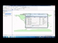 How to join an Excel spreadsheet onto an attribute table in ArcMap 10.0
 Creating / Editing Shapefiles in ArcMap
 Importing excel data into ArcMap|| importing Excel Data to ArcGIS
 Add "X" & "Y" data to Arcgis (10.4)
 How to import Excel data to Google Earth
 GIS Tutorial | Part 1 | How to make a shapefile or study area in ArcGIS
 QGIS | Add Excel or CSV and Export to SHP in QGIS 3.12
 A Complete Beginner's Guide to ArcGIS Desktop (Part 1)
 ArcMap Tutorial 4: Convert CSV to Shapefile
 Importing Excel Coordinates to ArcMap and Plotting
 Taking Coordinates from any shape in ArcGIS & export to other formats
 Change Projection - Coordinate System in ArcMap
 How to get Openstreetmap data in shapefile type
 Create polygon from points using X tool pro ArcGIS 10.1
 Spatial Queries, Table Joins, and Relates: A Technical Video Lecture
 Making CSV files for GIS
 A Complete Beginner's Guide to ArcGIS Desktop (Part 2)
 Convert GPS Coordinates Data to Shapefile using ArcGIS