GIS Tutorial | Part 1 | How to make a shapefile or study area in ArcGIS
This is the ABC of learning GIS. In this video I used arcGIS10.1.
To get more videos, subscribe to the channel.
GIS Tutorial Part-2:
https://www.youtube.com/watch?v=tmJO-gbdJj0&t=8s&fbclid=IwAR3-7fkAmpr7_N4vmCoyCY8TOTTlzW2GbeItMV-tWuOOofmE-pd1IrYqWDE
World country map: https://drive.google.com/open?id=16-qcZ_N8dyaSjkxse05MHCFccJPSsjo9
Diva GIS: http://www.diva-gis.org/
Thanks for watching.....
Видео GIS Tutorial | Part 1 | How to make a shapefile or study area in ArcGIS канала Learn GIS & R
Показать
Комментарии отсутствуют
Информация о видео
Другие видео канала
 A Complete Beginner's Guide to ArcGIS Desktop (Part 1)
 GIS tutorial | Part 2 | Download high-resolution satellite image from Google Earth Pro | ArcGIS
 Creating / Editing Shapefiles in ArcMap
 Introduction to GIS
 QGIS 3 for Absolute Beginners
 How to make a study area on ARC GIS in Amharic በ ARCGIS ላይ የጥናት ቦታ እንዴት እንደሚሰራ
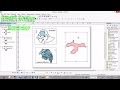 Study Area Mapping Using ArcGIS
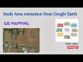 Study Area extraction from Google Earth and Export in ArcMap
 An Absolute Beginner's Guide to QGIS 3
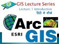 ArcGIS Lecture 1 Introduction
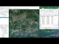 Importing Excel Coordinates to ArcMap and Plotting
 How to Georeference an Image or a Scanned Map using ArcMap
 GIS lecture 3 Shape file creation
 GIS Tutorial | Part 08 | Create Spatial Distribution Map | ArcGIS | Interpolation | Spatial Analysis
 ArcGIS Create A Map Layout.
 GIS Tutorial | Part 4 | Creating basemap or study area from georeferenced satellite image | ArcGIS
 Study Area Mapping | Create Map Layout in ArcGIS
 Making GIS Map using Google Earth Pro and QGIS
 Introduction to Geographic Information Systems (GIS) Software: An Open Source Lecture #GIS #Maps
 How to Download TRMM Precipitation Data and Estimate Erosivity Factor in ArcMap