Basic GPR Data Processing using Geolitix
Learn the basics of processing GPR data, from gaining to slicing, using Geolitix cloud-based geophysical software.
Ground Penetrating Radar (GPR) is a geophysical technique that uses radio waves to make observations of the subsurface. GPR is the most used geophysical method used by many different professionals for purposes such as geologic studies, to locate utilities, for rebar scanning, roadway integrity assessment, archaeological investigations, and much more.
For more Geolitix support:
https://docs.geolitix.com/
00:00 | Intro
01:07 | Creating a project
02:00 | Uploading files
02:52 | Data positioning
03:50 | Radargram processing (constant scale gain)
05:06 | Radargram processing (energy decay gain)
05:51 | Radargram processing (time zero correction)
06:14 | Radargram processing (background subtraction)
07:00 | Radargram observations
09:50 | Point interpretations
11:35 | Horizon interpretations
12:52 | Setting project velocity
16:06 | Radargram processing for slices (migration and Hilbert transform)
18:05 | Navigating the world tab
19:05 | Creating slices
22:37 | Creating a depth grid
24:32 | Sharing a Geolitix project
24:44 | Leveraging the capabilities of Geolitix
Give yourself every advantage by using GPR software that does the heavy lifting for you:
https://geolitix.com/
*This video is not sponsored by Geolitix
Land Magnetometer Basic Data Processing how-to video (Geometrics G-864 Magnetometer):
https://youtu.be/pRzndx5H9Zo
#geophysics #groundpenetratingradar #GPR
GPR data processing steps
GPR data processing software
GPR data interpretation
ground penetrating radar processing
Видео Basic GPR Data Processing using Geolitix канала Stefan Burns
Показать
Комментарии отсутствуют
Информация о видео
Другие видео канала
 What are Solar Storms, Flares, and Coronal Mass Ejections?
 YOGA for Circulating and Balancing Energy | Mudras, Fascia, and Ojas
 Reishi Mushroom Complete Guide: Health, Preparation, Uses, Chemicals 🍄
 Miraculous Healing Power of Vibration with Phil Jacobs | Stefan Burns Live #10
 Binaural Beats for Success: Schumann Resonances 7.8, 14, 20, 26.5, 33 Hz Progression
 Elderberry | Nature's Best Anti-Viral
 Uranus's Dynamic Magnetosphere and Planetary Conditions
 PEMF + Massage activates deep cellular regeneration - Is this the ultimate recovery tool?
 Gut Health and Microbiome Basics - The Main Factors at Play
 Chamomile Herbalism - Azulenes, Health Benefits, & Uses
 Science of Schumann resonances and brain electromagnetic interactions
 Yoga and Calisthenics for Spiritual Evolution | Stefan Burns Live #8
 Some gardening wisdom I wish I knew as a beginner
 How Space Weather & Geomagnetic Storms change Brainwaves and upgrade Consciousness
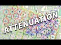 Differences Between 4G and 5G
 BREAKING! High chance of G4/G5 Geomagnetic Storms next Week
 4.5 X-Class Solar Flare EXPLODES - Geomagnetic Storms Inbound
 Earth's Biggest Secrets are being Revealed by Magnetic Anomalies
 Solar Activity and Astrology are linked, maybe...
 Guide to Manifesting with Water 💦
 Is Earth a Super-Consciousness? If so, what is she thinking and feeling?