The Mojave River: A 3D Journey
Created by the USGS, in cooperation with the Mojave Water Agency
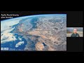
The animation opens with an aerial view of western San Bernardino County, California. The map displays county boundaries, cities, seven dry lakes, and intermittent and perennial streams. The map then zooms into the length of the Mojave River channel. The Mojave River is the largest of the streams and rivers that flow through the area and extends more than 100 miles east from its source in the San Bernardino Mountains to the end east of Afton Canyon (Thompson, 1929; Lines, 1996).
Next, locations of points of interest appear on the map, including Mojave Forks Dam, Mojave Water Agency, Upper Narrows, Lower Narrows, and Afton Canyon. The floodplain aquifer boundary is then displayed, as is the surface water and groundwater monitoring sites in the area. The cities, dry lakes, points of interest, the river channel, and the monitoring sites remain visible for the duration of the river tour.
The fly-through tour then begins, providing a 3D topographic view of the entire river channel length, which is dry for the entire length. The animation begins at the junction of Deep Creek and West Fork Mojave River at Mojave River Forks Reservoir located at the northern foot of the San Bernardino Mountains at an elevation of about 3,000 feet above sea level. From the reservoir, the river generally flows northward through the city of Victorville. The animation slows down as it approaches and travels through the Upper and Lower Narrows (small canyons). The tour continues generally north and northeastward through the city of Barstow and, eventually through Afton Canyon. After emerging from Afton Canyon, the river splits into separate channels leading to East Cronise Lake and Soda Lake.
Videographer: Sally House
USGS California Water Science Center
shouse@usgs.gov
Video download: https://www.usgs.gov/media/videos/mojave-river-a-3d-journey
Видео The Mojave River: A 3D Journey канала USGS
Показать
Комментарии отсутствуют
Информация о видео
Другие видео канала
 PubTalk 5/2021 - Where Earthquakes Hide in the Desert
 Routine overflight of Halema`uma`u crater
 Studying How the Beach Changes at Madeira Beach, Florida
 John Wesley Powell, Canyon Geologist
 Mount St. Helens: May 18, 1980
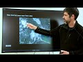 The Yellowstone Volcano Observatory: Overview, Monitoring, Hazards, and Noteworthy Results
 Colorado River: Spring Disturbance Flow
 Lake Mead: Clear and Vital
 Ice breakup on the Skunk River at Augusta, IA
 Monthly update of activity at Yellowstone Volcano for June 2021
 What Does a USGS Hydrologic Technician Do to Inspect Streamgages?
 May the Quartz Be With You
 Kīlauea lower East Rift Zone 2019: quiet but insightful
 A virtual walk through Kīlauea Volcano’s summit history: Part 2
 Kīlauea Summit Eruption | Lava Returns to Halemaʻumaʻu
 IRIC Pilot Applications for the Potomac River Using Bathy-Lidar Data
 We are the Coastal and Marine Hazards and Resources Program
 YVO Update of Activity at Yellowstone and Plans for Summer Fieldwork
 Monthly update of activity at Yellowstone Volcano for July 2021