YVO Update of Activity at Yellowstone and Plans for Summer Fieldwork
It's May, the snow is melting and the roads are mostly open, so it's time for geologists, geophysicist and geochemists to head into Yellowstone to start projects they have been planning for the last several months. Next week, a field team will deploy a temporary GPS network to help “densify” the network of continuous GPS stations already in place. The temporary GPS stations are low profile, low power, aren't radio connected, and will need to be picked up later this year before the snow starts to fall. Each station has a solar panel and a battery pack that powers the instrumentation, and a GPS antenna that sits quite close to the ground. Listen, as Mike Poland, the scientist-in-charge of the Yellowstone Volcano Observatory talks about future field plans and recent activity at Yellowstone, in the YVO monthly update for May 1, 2021.
Video: https://www.usgs.gov/media/videos/yvo-update-activity-yellowstone-and-plans-summer-fieldwork
Видео YVO Update of Activity at Yellowstone and Plans for Summer Fieldwork канала USGS
Video: https://www.usgs.gov/media/videos/yvo-update-activity-yellowstone-and-plans-summer-fieldwork
Видео YVO Update of Activity at Yellowstone and Plans for Summer Fieldwork канала USGS
Показать
Комментарии отсутствуют
Информация о видео
Другие видео канала
 Mount St. Helens: May 18, 1980
 Yes! Yellowstone is a Volcano
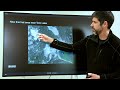 The Yellowstone Volcano Observatory: Overview, Monitoring, Hazards, and Noteworthy Results
 Grizzly Bear with Cubs Charges Wolf
 Mitigating Hazards at Cascade Range Volcanoes
 The Yellowstone Volcano: Past, Present and Future
 Hayward Fault - A virtual tour demonstration
 YVO Update: Activity at Yellowstone and Volcanoes of Desert Southwest
 Transitions: What's next for HVO and the volcanoes it monitors?
 Yellowstone Volcano Observatory Monthly Update for January 2021
 Forecasting Ashfall Impacts from a Yellowstone Supereruption
 The 20th Century's Greatest Volcanic Eruption: Mt Katmai 100 Years Later
 Apr 27, 2021 Generalizing the NHDPlus HR for National Applications
 Digitize an Analog Map With GeMS, Part B1
 Getting Started With GeMS, Part A
 Digitize an Analog Map With GeMS, Part B3
 USGS Missouri River Dye Tracing Assessment