Image of the Week - Dixie Fire Ravages Northern California
The Dixie Fire has become the largest single fire in California's recorded history. State fire officials don't list it at the top, however. The record is held by the massive August Complex fire of 2020 which burned over one million acres. The term "complex" is used when multiple fires in the same area ignite separately. Designating the fires as a complex allows them to be managed under a unified command.
The Dixie Fire ignited on July 13th, 2021 near Cresta Dam in the Feather River Canyon. 9 days later the Fly Fire started 3.5 miles north of Quincy eventually merging into the much larger Dixie Fire. Hot weather and strong winds spread the blaze across national forest and into Lassen Volcanic National Park.
These near-infrared and shortwave infrared images cut through smoke to highlight burned areas, while natural color versions of these scenes expose the massive amounts of smoke generated.
Contact: USGS EROS Center, eroscommunications@usgs.gov
Additional Credits: Writer - Tom Adamson (Contractor to EROS)
Video download: https://www.usgs.gov/media/videos/image-week-dixie-fire-ravages-northern-california
EROS = Earth Resources Observation and Science Center
Видео Image of the Week - Dixie Fire Ravages Northern California канала USGS
Показать
Комментарии отсутствуют
Информация о видео
Другие видео канала
 Mount Rainier Lahars: Hazards for the Puyallup and Nisqually River Drainages
 YVO monthly update of activity at Yellowstone Volcano, May 1, 2022
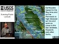 PubTalk 9/2018 - Hayward Earthquake
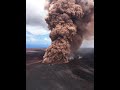 Largest Gravity Changes Ever Recorded: 2018 Kīlauea Eruption
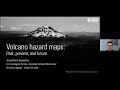 Volcano Hazard Maps: Past, Present, and Future
 A virtual walk through Kīlauea Volcano’s summit history: Part 3
 A virtual walk through Kīlauea Volcano’s summit history: Part 2
 Lava lake at Kīlauea summit on April 26, 2022
 PubTalk 11/2019 — Sea-Level Rise, Extreme Water Levels, and Coastal Erosion...How bad could it be?
 Mitigating Hazards at Cascade Range Volcanoes
 The building and upkeep of landslide hazards program: Blue Ridge perspective on a national challenge
 An overview of landslide hazards in Idaho
 The story of Yellowstone's ups and downs
 Landsat: Celebrating 50 Years
 Kīlauea summit overflight video – May 10, 2022
 Calwood Fire, Calwood post-fire debris-flow monitoring station, July 31, 2021
 Alaska landslides—A challenge for the Last Frontier
 PubTalk-04/2022 - A Burning Question: What can long-term datasets teach us?
 LGSOWG 50th Anniversary