A virtual walk through Kīlauea Volcano’s summit history: Part 3
Join USGS Hawaiian Volcano Observatory scientist emeritus Don Swanson on a virtual walk, during which you learn about the past 500 years of Kīlauea Volcano’s history as revealed by rocks, craters, and cracks.
This virtual walk will be released in three parts, covering different sections of the Keanakākoʻi Crater trail. Along the walk, Don points out and explains some of the features that formed during the 2018 summit collapse events, as well as the best publicly accessible display of explosive deposits erupted from Kīlauea around 230–370 years ago, one of which probably relates to an important oral tradition. Don also shows two contrasting vents for the July 1974 eruption, highlights the thick deposit of pumice and scoria erupted in 1959, and ponders the origin of Keanakākoʻi Crater.
You can visit the Hawaiʻi Volcanoes National Park website (https://www.nps.gov/havo/planyourvisit/keanakakoi.htm) to learn about walking the 2-mile round-trip Keanakākoʻi Crater trail, which begins at the Devastation Trail parking lot on Crater Rim Drive in Hawaiʻi Volcanoes National Park (Map: https://www.nps.gov/havo/planyourvisit/upload/HAVO-Unigrid-Brochure-2019.jpg).
Video: https://www.usgs.gov/media/videos/a-virtual-walk-through-k-lauea-volcano-s-summit-history-part-3
Видео A virtual walk through Kīlauea Volcano’s summit history: Part 3 канала USGS
Показать
Комментарии отсутствуют
Информация о видео
Другие видео канала
 2017 May Evening Public Lecture
 PubTalk 8/2018 - Volcanoes
 Kīlauea Summit Eruption | Lava Returns to Halemaʻumaʻu
 A virtual walk through Kīlauea Volcano’s summit history: Part 1
 A virtual walk through Kīlauea Volcano’s summit history: Part 2
 Forecasting Ashfall Impacts from a Yellowstone Supereruption
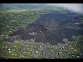 Kīlauea lower East Rift Zone 2019: quiet but insightful
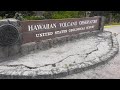 Transitions: What's next for HVO and the volcanoes it monitors?
 USGS Public Lecture: Warm Ice—Dynamics of Rapidly Changing Glaciers
 PubTalk 5/2018 - Earthquakes
 July Evening Public Lecture — USGS California Volcano Observatory: It's not just earthquake country!
 The Yellowstone Volcano: Past, Present and Future
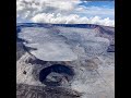 When will Mauna Loa erupt next?
 What can lava tell us? Deciphering Kīlauea’s 2018 eruption through chemistry
 Automating Validation and Update of the NHD
 Largest Gravity Changes Ever Recorded: 2018 Kīlauea Eruption
 PubTalk 9/2018 - Hayward Earthquake
 The 20th Century's Greatest Volcanic Eruption: Mt Katmai 100 Years Later
 Ice breakup on the Skunk River at Augusta, IA